
Grid Systems and Coordinates
What is a grid system?
A grid is a regular pattern made of squares formed by two sets of lines that intersect at right angles. Grid systems are used to precisely identify locations on a map. The two types of grid systems we will cover in this course are:
- Geographic, where locations are specified using degrees and minutes of latitude and longitude.
- Universal Transverse Mercator (UTM), where locations are specified in metres using an easting and northing.
Depending on your settings in Google Earth Pro, you might be using the geographic grid system (latitude and longitude) OR the Universal Transverse Mercator grid system (UTM). If you are not sure which grid system you are using, return to the Options menu to check.
Latitude and longitude
The geographic grid system is made up of meridians of longitude and parallels of latitude. Figures T8 and T9 illustrate the geographic grid system in Canada.
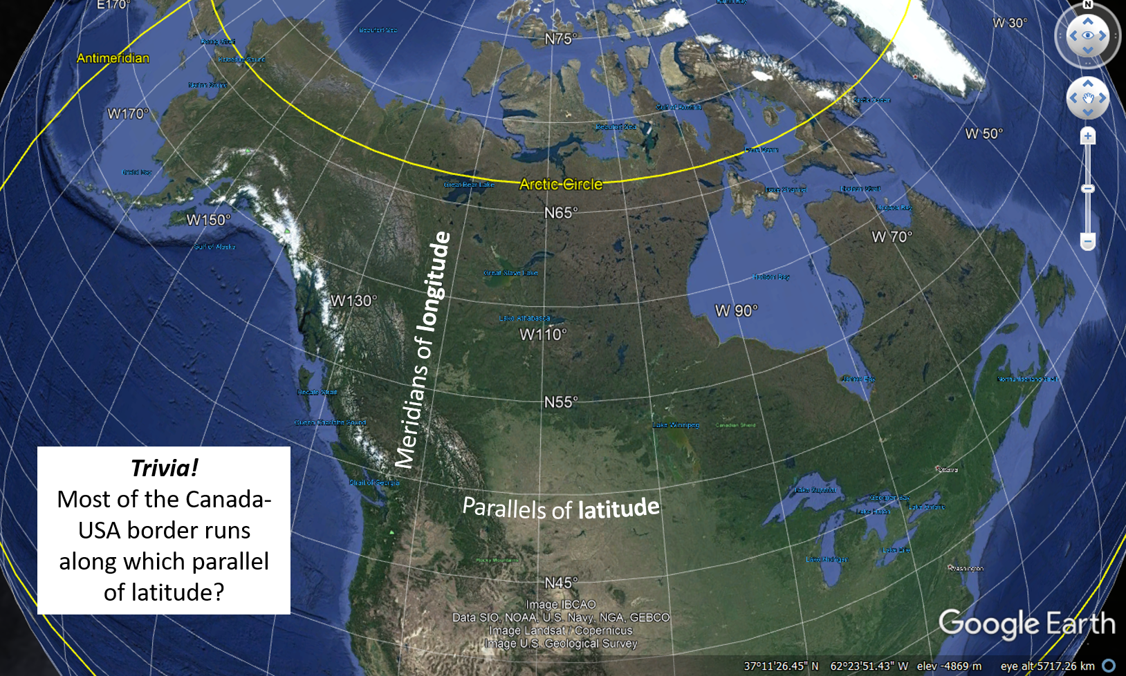

Coordinates that describe an exact location on the surface of Earth are represented in degrees, minutes and seconds of latitude and longitude. Depending on the accuracy required in locating a point on a map, degrees (°) may be subdivided into 60 subdivisions known as minutes (‘) and minutes may be subdivided into 60 subdivisions known as seconds (“). The line of 0° longitude is the prime meridian located in Greenwich, England, and longitude increases from 0° to 180° as you move east or west away from the prime meridian. The line of 0° latitude is the equator, and latitude increases from 0° to 90° as you move north or south towards the poles.
When using the geographic grid system, one must specify whether coordinates are north (N) or south (S) of the equator, and east (E) or west (W) of the prime meridian. For anywhere in Canada, latitude will always be north of the equator and longitude will always be west of the prime meridian, e.g., 51°02’39” N 114°03’47” W. Notice that latitude is listed first, followed by longitude. Together, these coordinates describe an exact location.
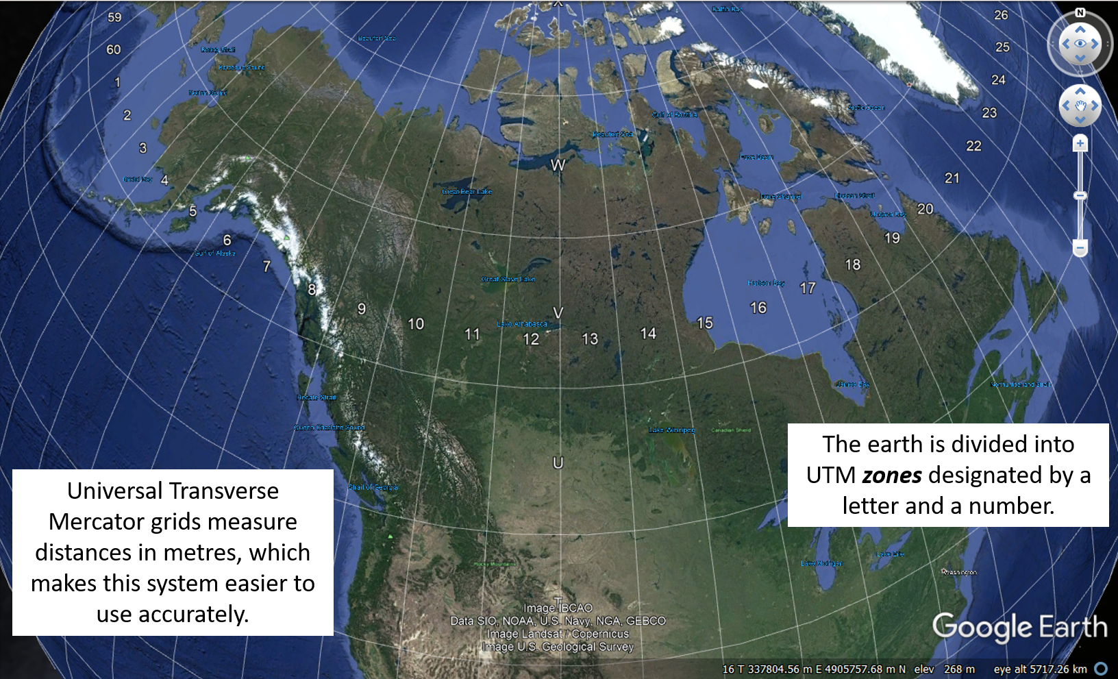
Universal Transverse Mercator (UTM)
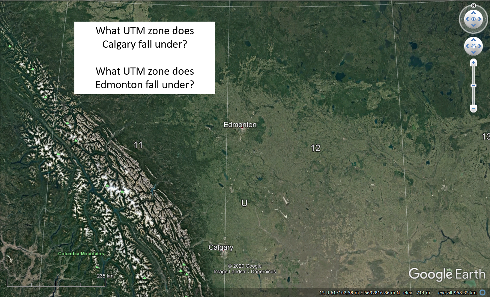
In this grid system designed by the military, Earth’s surface is divided into 60 north-south zones designated by a number and letter, each covering 6° of longitude in width (Figure T10). Inside each zone, coordinates are measured in metres north and east. The city of Calgary is actually divided into two UTM zones: zone 11 U and zone 12 U (Figure T11).
A UTM coordinate always begins with the zone, which in the case for most of Calgary is 11 U. The easting is always given first, followed by the northing. For example, 11 U 705863 m E 5658841 m N are the approximate coordinates for the Calgary Tower.
In Figure T12, a point is located using UTM coordinates 11 U 708400 m E 5659200 m N, meaning that the location is known to within a 100 m by 100 m square. If you were using GPS to pin-point your location, you might be able to record UTM coordinates to within a 1 m by 1 m square, and your coordinates might look something like: 11 U 708411 m E 5659284 m N. Note that the UTM system is a true metric measuring system, and that it is the easiest to use accurately.
Universal Transverse Mercator (UTM) grid references
Instead of reporting the full UTM coordinates, an abbreviated 6-digit grid reference can be reported to give a location to nearest 100 m. To report an abbreviated grid reference, look at the nearest grid line and estimate tenths of a square eastward or northward from this line to the location of interest. Record the UTM zone followed by the three digits in the 10000, 1000 and 100 position for both the easting and the northing.
For example, the full UTM coordinates 11 U 708411 m E 5659284 m N can be abbreviated using only the bolded and underlined portions of the full coordinates, 11 U 084592.
Using grid coordinates to find a location
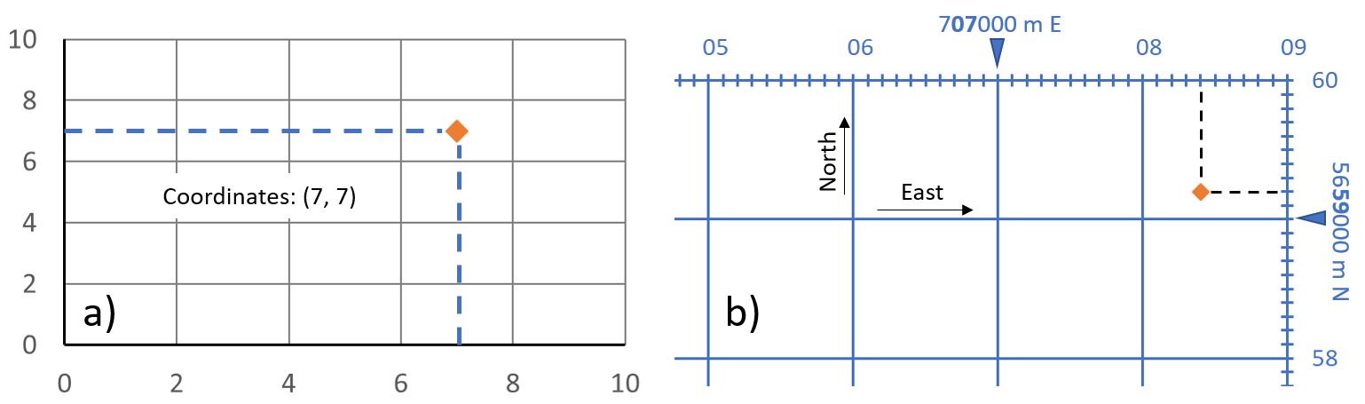
Using coordinates to specify a position in a grid is just like locating a point on a simple X-Y graph. On an X-Y graph, the first number in the coordinate refers to the position along the X-axis and the second number refers to the position along the Y-axis (Figure T12 a). To use coordinates in a geographic grid system, simply use the labeled grid lines or graticules around the outer border of a map and plot the longitude first, followed by the latitude. To use coordinates in a UTM grid system, simply use the labeled grid lines or graticules around the outer border of a map and plot the easting first, followed by the northing (Figure T12 b).
Your turn to practice finding and describing locations using grid coordinates
- What are the UTM coordinates (easting and northing) of the point in Figure T12 b?
- Try plotting the coordinate 11 U 707500 m E 5658200 m N on Figure T12 b.
- In the UTM grid shown in Figure T12 b, what is the length in metres of each side of each square on the grid?
- To see the grid lines for each system in Google Earth, click on View, Grid. Try zooming in and out to see how each grid type looks. Try this using the geographic grid (lat/long) and the UTM grid.
- Type “Mount Royal University” into the search bar and click Search. Hover your cursor right on the place marker. What are the coordinates for MRU in lat/long? Remember, you must specify that MRU is north of the equator and west of the prime meridian!
- What are the coordinates for MRU in UTM coordinates? Remember, you must specify the zone number!
- What are the coordinates for MRU in UTM as a grid reference? Remember, you must specify the zone number!
See Appendix 2 for Google Earth Tutorial answers.
Media Attributions
- Figures T8, T9, T10, T11 used under the following Google Maps and Google Earth guidelines.
- Figure T12: © Siobhan McGoldrick. CC BY.
A grid system used to specify locations on Earth using coordinates of latitude and longitude.
A measurement of the angular distance north or south from the equator of a point on Earth's surface. Coordinates are reported in degrees, minutes, and seconds.
A measurement of the angular distance on Earth's surface east or west from the Prime Meridian in Greenwich, England. Coordinates are reported in degrees, minutes, and seconds.
A grid system used to specify locations on Earth's surface using easting and northing coordinates measured in metres.
The eastward-measured distance, or x-coordinate, used in the Universal Transverse Mercator (UTM) grid system. Reported in metres.
The northward-measured distance, or y-coordinate, used in the Universal Transverse Mercator (UTM) grid system. Reported in metres.
Imaginary lines that run north-south and are used to measure longitude in the geographic grid system.
Imaginary lines that run east-west and are used to measure latitude in the geographic grid system.
In the context of the geographic grid system, a distance equal to 60 minutes.
In the context of the geographic grid system, a distance equal to 60 seconds.
In the context of the geographic grid system, a measurement of distance. Sixty seconds corresponds to one minute.
The line of longitude defined to be 0°. Located in Greenwich, England.
Parallel of latitude defined to be 0°.
A shortened version of full UTM coordinates for a specific location on Earth's surface.
