
Lab 10 Exercises
The ability to visualize strata in three-dimensions is a spatial skill that is fundamental to understanding geology in the real world. For some, this skill comes easily. Bur for others, spatial thinking and visualization can be difficult concepts, especially at first. Regardless of which category of student you fall into, while these skills may come more naturally to some, they can be taught and will improve with practice! To practice visualizing in three-dimensions, think about the difference between how an object looks from above (in plan view), and how a slice through that object would look (in cross-section).
Spatial thinking and cross-sections
Imagine an apple. How would the apple look in plan view?
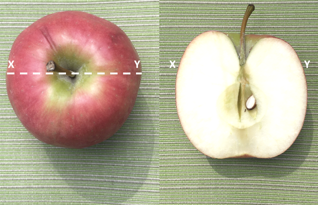
Now imagine slicing the apple in half, along a straight line. If you pull the two halves apart to examine the internal structure of the apple, you are looking at a cross-section. The photographs below show how the apple looks in plan view (left), and in cross-section (right). The dashed white line is the line of cross-section, from X to Y.
For more practice, imagine and sketch what the cross-section of the following objects would be:
- an orange
- a lemon cut in half from end to end
- a round loaf of sourdough bread, cut into slices
- a pyramid with a square base, cut along a diagonal line from corner to corner
Today you will use printed copies of the block models in Appendix 5 to explore geologic structures. Recall that the top surface of a block model represents the plan view of the Earth’s surface, and the four sides represent four cross-sectional views down into the subsurface. On each of the six block models below, the geology drawn on the south- and west-facing sides shows the geology of the subsurface. This will give you some clues about the attitude (dip and dip direction) of the formations, as well as any structures present. Examine each of the block models, complete the missing sides, and use your completed model to answer the questions below. Unless otherwise stated, assume all the formations below represent sedimentary rocks.
For some of the models you will be asked to write a point-form geologic history based on what you observe in the model. This is an excellent way to review the relative dating and geologic time concepts from Lab 7. For example, try writing a point-form geologic history for Block Model 1 that shows a sequence of Cambrian (brown), Ordovician (light grey), Silurian (cream), Devonian (blue grey), and Mississippian (orange) formations that are dipping to the east, as well as a Cretaceous gabbro dyke (dark brown).
A point-form geologic history for Block Model 1 would look something like this:
Youngest (most recent)
- Erosion +/- uplift to present
- Intrusion of Cretaceous gabbro dyke (cross-cutting relationships)
- Tilting of the Cambrian to Mississippian formations toward the east (original horizontality)
- Deposition and lithification of the Mississippian formation (superposition)
- Deposition and lithification of the Devonian formation (superposition)
- Deposition and lithification of the Silurian formation (superposition)
- Deposition and lithification of the Ordovician formation (superposition)
- Deposition and lithification of the Cambrian formation (superposition)
Oldest
Notice how the history is formatted such that the oldest event is at the bottom, and the youngest or most recent event is listed at the top. The italic font in parentheses indicates the principle of stratigraphy used to justify the position of each event in the timeline. Also note that the terms used to describe the different geologic events match the type of rocks: deposition for sedimentary rocks, intrusion for the igneous dyke. Recall from Lab 3, that gabbro is a mafic intrusive igneous rock, that cooled beneath the Earth’s surface. Since the gabbro dyke is now exposed at the surface of the Earth, the most recent event must be that the area has been uplifted and any overlying rocks or sediment have been eroded away.
Block model 1
Cut out block model 1, then construct the model by folding along the red lines. Fold in the corners of the model to create a 3D rectangular shape. Do not staple or tape the corners yet, as the model is easier to complete when laid flat on a hard surface. Later, you may want to staple or tape these corners so that your model maintains its shape.
This model shows a sequence of Cambrian (brown), Ordovician (light grey), Silurian (cream), Devonian (blue grey), and Mississippian (orange) formations that are dipping to the east. A Cretaceous (dark brown) dyke is also shown.
- Complete the north- and east-facing sides of the block by drawing in the geology. You do not need to colour in the block model, but your formations must be labeled.
- Draw a black arrow in plan view to indicate the dip direction of the Ordovician formation (O) at point i.
- Using your protractor, measure the dip of the Ordovician formation on the south-facing side of the block. Remember, dip is measured in degrees from horizontal (0°) down to the inclined plane. Review Figures 9.1.2 and 9.1.3 if you are unsure where the angle of dip should be measured on your block model. Dip:
- Draw a black arrow in plan view to indicate the dip direction of the Cretaceous dyke (K) at point ii.
- Using your protractor, measure the dip of the Cretaceous dyke on the south-facing side of the block. Dip:
Block model 2
This model shows a sequence of Cambrian (brown), Ordovician (cream), Silurian (light grey), and Devonian (blue grey) formations. This model is a little more complex than Model 1, as the strata here have been folded.
- Complete the north- and east-facing sides of the block by drawing in the geology. You do not need to colour in the block model, but your formations must be labeled.
- Draw a black arrow in plan view to indicate the dip direction(s) of the Silurian formation (S) at points i, ii, and iii.
- Draw on the axial plane for each fold in red pen on the south- and north-facing sides of the model.
- In plan view and using a ruler, draw the surface traces of the axial planes for the folds in red pen. Add the appropriate symbols to indicate the type of fold (see Figure 10.2.5).
- What type of stress is required to produce the geologic structures observed in this block model?
Block model 3
This model shows a faulted sequence of Cambrian (green), Ordovician (blue), Silurian (grey), and Devonian (cream), and Mississippian (brown) formations. Examine the offset of the formations shown in the south-facing side of the block.
- Complete the north- and east-facing sides of the block by drawing in the geology. You do not need to colour in the block model, but your formations must be labeled.
- Draw a black arrow in plan view to indicate the dip direction of the Mississippian formation (M) at point i.
- Draw a black arrow in plan view to indicate the dip direction of the fault at point ii.
- Draw a black arrow in plan view to indicate the dip direction of the Silurian formation (S) at point iii.
- Label the hanging wall and footwall on the south- and north-facing sides of the model (the blocks above and below the fault).
- Draw red arrows on either side of the fault to indicate the sense of displacement along the fault.
- Is the fault in this model a normal or reverse fault? Why?
- Draw the appropriate map symbol for the fault in plan view. Consult Figure 10.3.4 for more information on map symbols for faults.
- What type of stress is required to produce the fault observed in this block model?
Block model 4
This model shows a faulted sequence of Cambrian (green), Ordovician (blue), Silurian (grey), and Devonian (cream), and Mississippian (brown) formations. Examine the offset of the formations shown in the south-facing side of the block.
- Complete the north- and east-facing sides of the block by drawing in the geology. You do not need to colour in the block model, but your formations must be labeled.
- Draw a black arrow in plan view to indicate the dip direction of the Mississippian formation (M) at point i.
- Draw a black arrow in plan view to indicate the dip direction of the fault at point ii.
- Draw a black arrow in plan view to indicate the dip direction of the Ordovician formation (O) at point iii.
- Label the hanging wall and footwall on the south- and north-facing sides of the model (the blocks above and below the fault).
- Draw red arrows on either side of the fault to indicate the sense of displacement along the fault.
- Is the fault in this model a normal or reverse fault? Why?
- Draw the appropriate map symbol for the fault in plan view. Consult Figure 10.3.4 for more information on map symbols for faults.
- What type of stress is required to produce the fault observed in this block model?
Block model 5
This model shows a faulted sequence of Cambrian (orange), Devonian (grey), and Mississippian (cream) formations, as well as a younger Cretaceous dyke (dark brown). Examine the offset of the dyke shown in the south-facing side of the block.
- Complete the north- and east-facing sides of the block by drawing in the geology. You do not need to colour in the block model, but your formations must be labeled.
- What is the dip of the Mississippian formation (M) at point i? Dip:
- What is the dip and dip direction of the Cretaceous dyke (K) at point ii?
- Draw red arrows on either side of the fault at point iii to indicate the sense of displacement along the fault.
- What type of strike-slip fault is this? Why?
- Write a point-form geologic history for this block model. Be sure to specify any unconformities (if present), and which principles of stratigraphy you use as evidence for your timeline.
- What type of stress is required to produce the fault observed in this block model?
Block model 6
This is a structurally-complex block model. This model shows a deformed sequence of Cambrian (brown), Ordovician (cream), Silurian (pale grey), and Devonian (blue grey) formations, as well as a Jurassic dyke (dark brown). The black unit on the south-facing side labeled ‘M’ is a Mississippian sill, a type of igneous intrusion.
- Complete the north- and east-facing sides of the block by drawing in the geology. You do not need to colour in the block model, but your formations must be labeled.
- What is the dip of the Silurian formation (S) at points i and ii? Indicate the dip direction in plan view at points i and ii by drawing black arrows.
- Draw on the axial plane for the fold in red pen on the south- and north-facing sides of the model.
- In plan view and using a ruler, draw the surface trace of the axial plane for the fold in red pen. Add the appropriate symbol to indicate the type of fold.
- What is the dip and dip direction of the Jurassic dyke (J) at point iii?
- What is the dip and dip direction of the fault at point iv?
- Label the hanging wall and footwall on the east- and west-facing sides of the model.
- Draw red arrows on either side of the fault to indicate the sense of displacement along the fault.
- Is the fault in this model a normal or reverse fault? Why?
- Write a point-form geologic history for this block model. Be sure to specify any unconformities (if present), and which principles of stratigraphy you use as evidence for your timeline.
Media Attributions
- Figure A: © Siobhan McGoldrick. CC BY.
- Block Models 1, 2, 3, 4, 5, 6: © Siobhan McGoldrick. CC BY.
