1.2 Plates, Plate Motions, and Plate Boundaries
By the end of 1967 the Earth’s surface had been mapped into a series of plates. The major plates are Eurasia, Pacific, India, Australia, North America, South America, Africa, and Antarctic. There are also numerous small plates (e.g., Juan de Fuca, Cocos, Nazca, Scotia, Philippine, Caribbean), and many very small plates or sub-plates. For example the Juan de Fuca Plate is actually three separate plates (Gorda, Juan de Fuca, and Explorer) that all move in the same general direction but at slightly different rates.
Rates of motions of the major plates range from less than 1 cm/y to over 10 cm/y. The Pacific Plate is the fastest, followed by the Australian and Nazca Plates. The North American Plate is one of the slowest, averaging around 1 cm/y in the south up to almost 4 cm/y in the north. Plates move as rigid bodies, so it may seem surprising that the North American Plate can be moving at different rates in different places. The explanation is that plates move in a rotational manner. The North American Plate, for example, rotates counter-clockwise; the Eurasian Plate rotates clockwise.
Boundaries between the plates are of three types:
- divergent (i.e., moving apart),
- convergent (i.e., moving together), and
- transform (moving side by side).
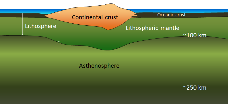
Before we talk about processes at plate boundaries, it’s important to point out that there are never gaps between plates. The plates are made up of the lithosphere. The lithosphere consists of the crust, which can be thin, relatively dense oceanic crust or thick, relatively buoyant continental crust, and the rigid uppermost part of the mantle (Figure 1.2.1). Even though tectonic plates are moving all the time, and in different directions, there is never a significant amount of space between them. Plates are thought to move along the lithosphere-asthenosphere boundary, as the asthenosphere is the zone of partial melting. It is assumed that the relative lack of strength of the partial melting zone facilitates the sliding of the lithospheric plates. The fact that the plates include both crustal material and lithospheric mantle material makes it possible for a single plate to be made up of both oceanic and continental crust. For example, the North American Plate includes most of North America (continental crust), plus half of the northern Atlantic Ocean (oceanic crust). The Pacific Plate is almost entirely oceanic, but it does include the part of California west of the San Andreas Fault.
Divergent Boundaries
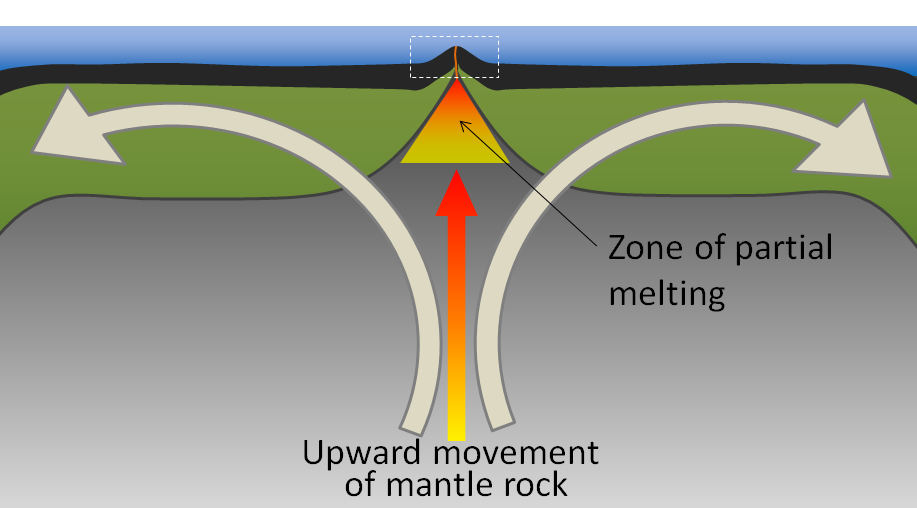
Divergent boundaries are spreading boundaries, where new oceanic crust is created from magma derived from partial melting of the mantle caused by decompression as hot mantle rock from depth is moved toward the surface (Figure 1.2.2). The triangular zone of partial melting near the ridge crest produces oceanic crust that is about 6 km thick. Most divergent boundaries are located at the oceanic ridges, although some are on land.
Convergent Boundaries
Convergent boundaries, where two plates are moving toward each other, are of three types, depending on whether oceanic or continental crust is present on either side of the boundary. The types are: ocean-ocean, ocean-continent, and continent-continent.
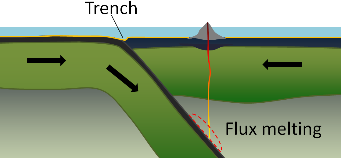
At an ocean-ocean convergent boundary, one of the plates (oceanic crust and lithospheric mantle) is pushed, or subducted, under the other. Often it is the older and colder plate that is denser and subducts beneath the younger and hotter plate. There is commonly an ocean trench along the boundary. The significant volume of water within the subducting material is released as the subducting crust is heated. The water that is released rises and mixes with the overlying mantle. The addition of water to the hot mantle lowers the rocks’s melting point and leads to the formation of magma (flux melting) (Figure 1.2.3). The magma, which is lighter than the surrounding mantle material, rises through the mantle and the overlying oceanic crust to the ocean floor where it creates a chain of volcanic islands known as an island arc.
As described above in the context of Benioff zones (Figure 1.1.3), earthquakes take place close to the boundary between the subducting crust and the overriding crust. The largest earthquakes occur near the surface where the subducting plate is still cold and strong.
At an ocean-continent convergent boundary, the oceanic plate is pushed under the continental plate in the same manner as at an ocean-ocean boundary. Sediment that has accumulated on the continental slope is thrust up into an accretionary wedge, and compression leads to deformation within the continental plate (thrust faults shown in Figure 1.2.4). The mafic magma produced adjacent to the subduction zone rises to the base of the continental crust and leads to partial melting of the crustal rock. The resulting magma ascends through the crust, producing a chain of volcanoes that form a continental arc.

A continent-continent collision occurs when a continent or large island that has been moved along with subducting oceanic crust collides with another continent (Figure 1.2.5). The colliding continental material will not be subducted because it is too light and buoyant, but the root of the oceanic plate will eventually break off and sink into the mantle. There is tremendous deformation of the pre-existing continental rocks, and creation of mountains from that rock, from any sediments that had accumulated along the shores of both continental masses, and commonly also from some ocean crust and upper mantle material.

Transform Boundaries
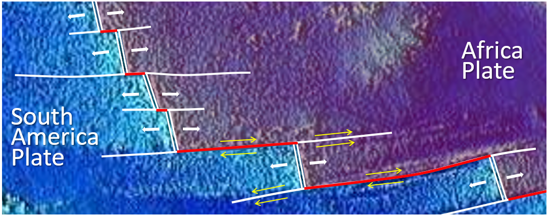
Transform boundaries exist where one plate slides past another without production or destruction of crustal material. Although oceanic spreading ridges appear to be curved features on Earth’s surface, in fact the ridges are composed of a series of straight-line segments, offset at intervals by faults perpendicular to the ridge (Figure 1.2.6). In a paper published in 1965, Tuzo Wilson termed these features transform faults.
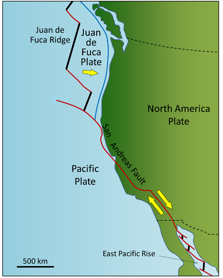
While most transform faults connect segments of mid-ocean ridges and are thus ocean-ocean plate boundaries, some transform faults connect continental parts of plates. An example is the San Andreas Fault, which extends from the southern end of the Juan de Fuca Ridge to the northern end of the East Pacific Rise (ridge) in the Gulf of California (Figure 1.2.7). The part of California west of the San Andreas Fault and all of Baja California are on the Pacific Plate. Transform faults do not just connect divergent boundaries. For example, the Queen Charlotte Fault connects the north end of the Juan de Fuca Ridge, starting at the north end of Vancouver Island, to the Aleutian subduction zone.
Media Attributions
- Figures 1.2.1, 1.2.2, 1.2.3, 1.2.4, 1.2.5, 1.2.6, 1.2.7: © Steven Earle. CC BY.
a plate boundary at which the two plates are moving towards away from each other
a plate boundary at which the two plates are moving towards each other
a boundary between two plates that are moving horizontally in opposing directions with respect to each other
The rigid outer part of the Earth, including the crust and the mantle down to a depth of about 100 kilometres.
The uppermost layer of the Earth, ranging in thickness from about 5 kilometres (in the oceans) to over 50 kilometres (on the continents).
The relatively thin and dense outermost layer of Earth's internal structure predominantly composed of mafic igneous rocks including gabbro intrusions, sheeted dikes, and pillow basalts. Formed by partial melting of the mantle beneath a spreading centre (ocean-ocean divergent boundary).
The relatively thick and buoyant outermost layer of Earth's internal structure composed of predominantly intermediate to felsic igneous rocks, as well as sedimentary and metamorphic rocks.
The middle layer of the Earth, dominated by iron and magnesium rich silicate minerals and extending for about 2900 kilometres from the base of the crust to the top of the core.
the part of the mantle, from about 100 to 200 kilometres below surface, within which the mantle material is close to its melting point, and therefore relatively weak
the process during which a only specific mineral components of a rock melt in response to changing conditions
melting (or partial melting) of rock resulting from a reduction in pressure without a significant reduction in temperature
When part of a plate is forced beneath another plate along a subduction zone.
melting of rock that is facilitated by the addition of a flux (typically water) which lowers the rocks melting point
A chain of volcanoes formed on the upper plate at a ocean-ocean convergent boundary. Volcanoes are built on oceanic crust.
the steeper part of a continental margin, that slopes down from a continental shelf towards the abyssal plain
In geology, deformation refers to folding (ductile bending) or faulting and fracturing (brittle breaking) of rocks in response to stress.
A chain of volcanoes formed on the upper plate at a ocean-continent convergent boundary. Volcanoes are built on continental crust.
a boundary between two plates that are moving horizontally with respect to each other in opposing directions
