
Lab 7 Exercises
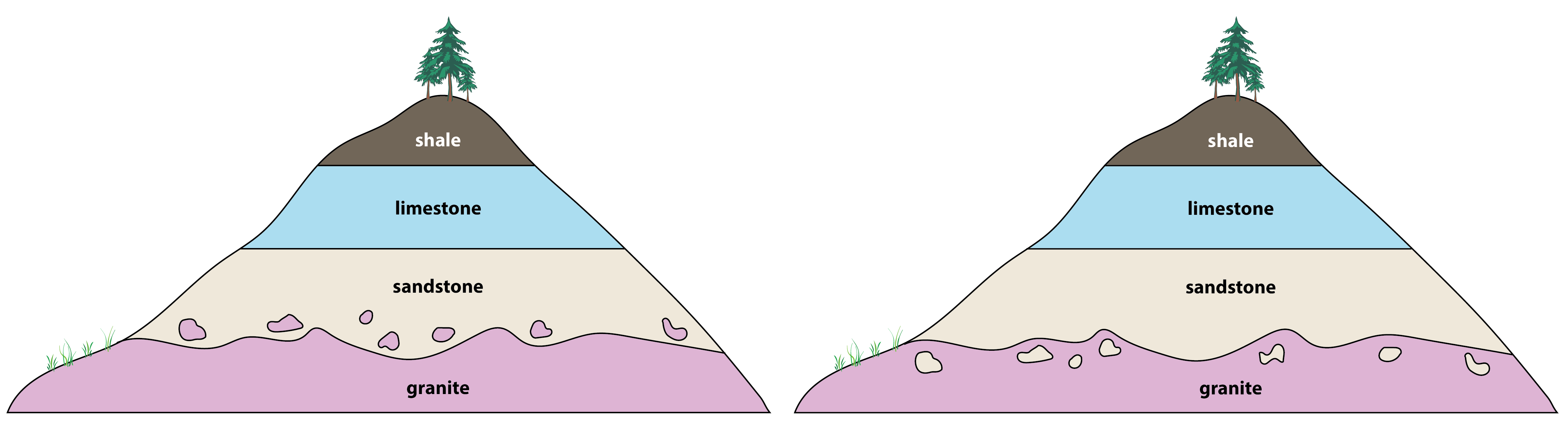
Figure A represents two road cuts, or cliff faces, exposed along a road way. You can see that at first glance, the road cuts look almost identical as they both expose the same four types of rock: granite, sandstone, limestone, and shale.
1. As a quick review from Labs 4, 5, and 6, how did each of these rocks form? Briefly summarize the origin of each rock in the table below.
| Rock Type | Granite | Sandstone | Limestone | Shale |
| Origin |
|
2. Examine the two road cuts carefully, and using the principles of stratigraphy, write a point-form geologic history for each road cut. A geologic history is a written sequence of events that describes what geological processes happened in the past to produce the stratigraphy in a given area, like a timeline. Your geologic history should use proper terms to describe each event. For example, we would say that a sedimentary rock was deposited and then lithified. We would not say that a sedimentary rock “intruded” or “erupted” because these terms are reserved for intrusive and extrusive igneous rocks, respectively. If there are any unconformities present, identify which type (review Figure 7.2.6) and briefly describe what the unconformity represents. This might include: a period of uplift and erosion, a period of non-deposition, or both.
| Youngest Event | Road Cut A (left) | Road Cut B (right) |
|
|
|
|
|
|
|
|
|
|
|
|
|
|
|
|
|
|
|
|
| Oldest Event |
|
|
3. Do the two road cuts share the same geologic history? Why or why not?
4. Which key principle of stratigraphy helped you determine the difference between the two road cuts?
Road cuts and naturally-occurring cliffs provide us with a view into the subsurface to help us understand the nature of the layers of rock beneath our feet. Another way to visualize the subsurface is using a block diagram, or block model (Figure B). The top of the diagram shows the plan view, or map view, of the Earth’s surface. The sides of the diagram show two different cross-sectional views down into the subsurface. These vertical cross-sections illustrate the geology below the surface.
We can see in Figure B, for example, that at the surface there is an active volcano (venting steam) that is connected at depth to a shallow magma chamber (E). The letters shown in this diagram, and in all the figures in this lab, are randomly assigned. In Figure B, layers G, H, J, and K are all sedimentary. Units B, C, D, E, L, and M are igneous.
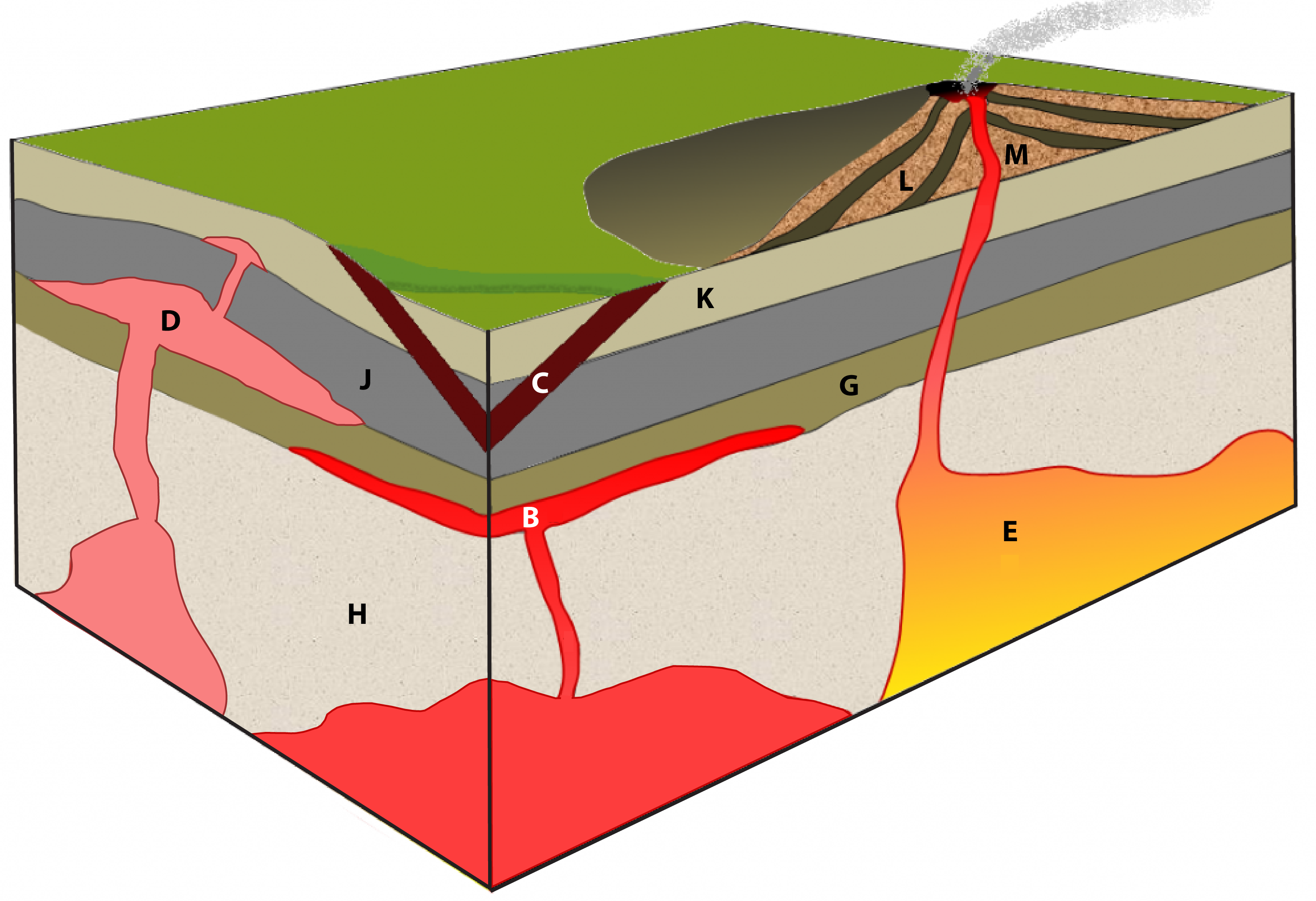
5. Write a point-form geologic history for Figure B in the table below. Specify which stratigraphic principle(s) you used to justify the position of each event in the timeline.
| Youngest Event | Geologic History of Figure B | Justification (which principle of stratigraphy did you use?) |
|
|
|
|
|
|
|
|
|
|
|
|
|
|
|
|
|
|
|
|
|
|
|
|
|
|
|
|
|
|
|
|
|
|
|
|
| Oldest Event |
|
|
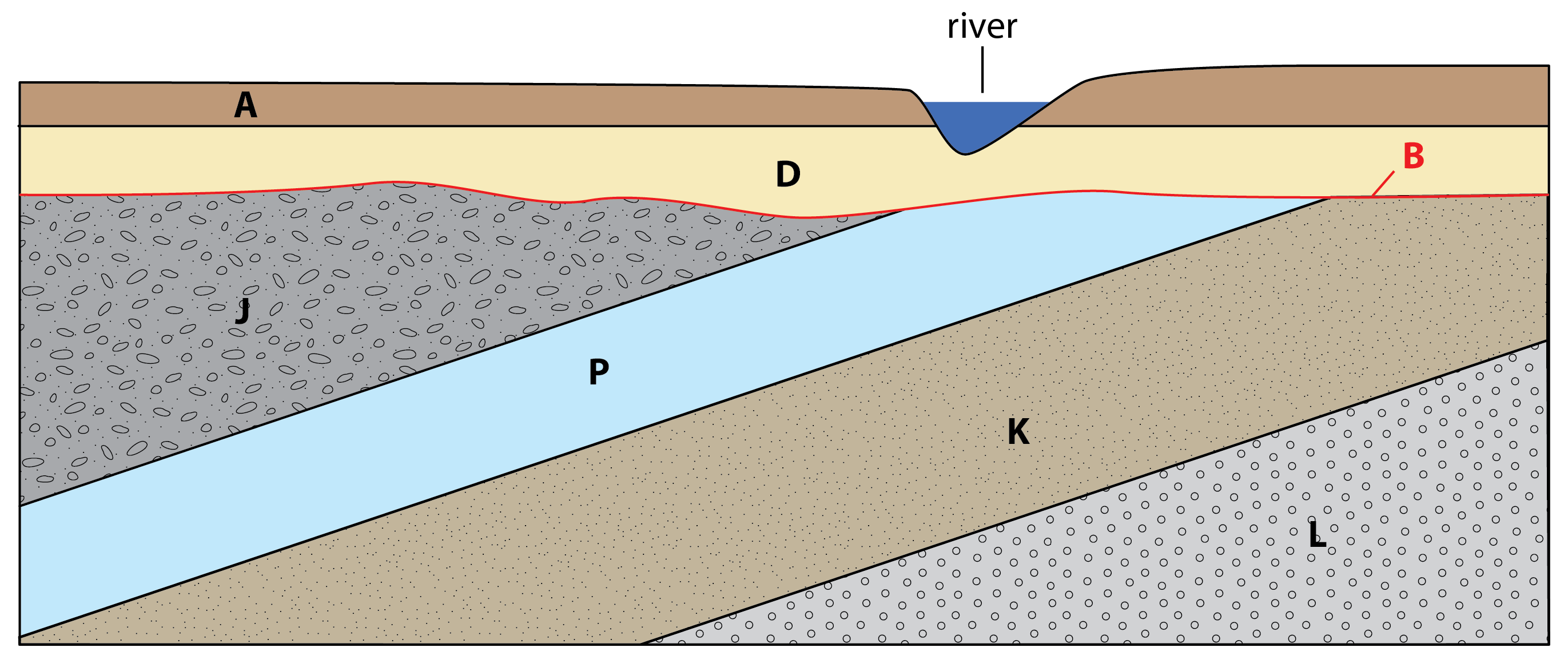
6. Write a point-form geologic history for Figure C in the table below. Specify which stratigraphic principle(s) you used to justify the position of each event in the timeline. If there are any unconformities present, identify which type and briefly describe what the unconformity represents. This might include: a period of uplift and erosion, a period of non-deposition, or both. All the units in Figure C are sedimentary rocks, except B which represents an erosional surface.
| Youngest Event | Geologic History of Figure C | Justification |
|
|
|
|
|
|
|
|
|
|
|
|
|
|
|
|
|
|
|
|
|
|
|
|
|
|
|
|
|
|
|
|
| Oldest Event |
|
|
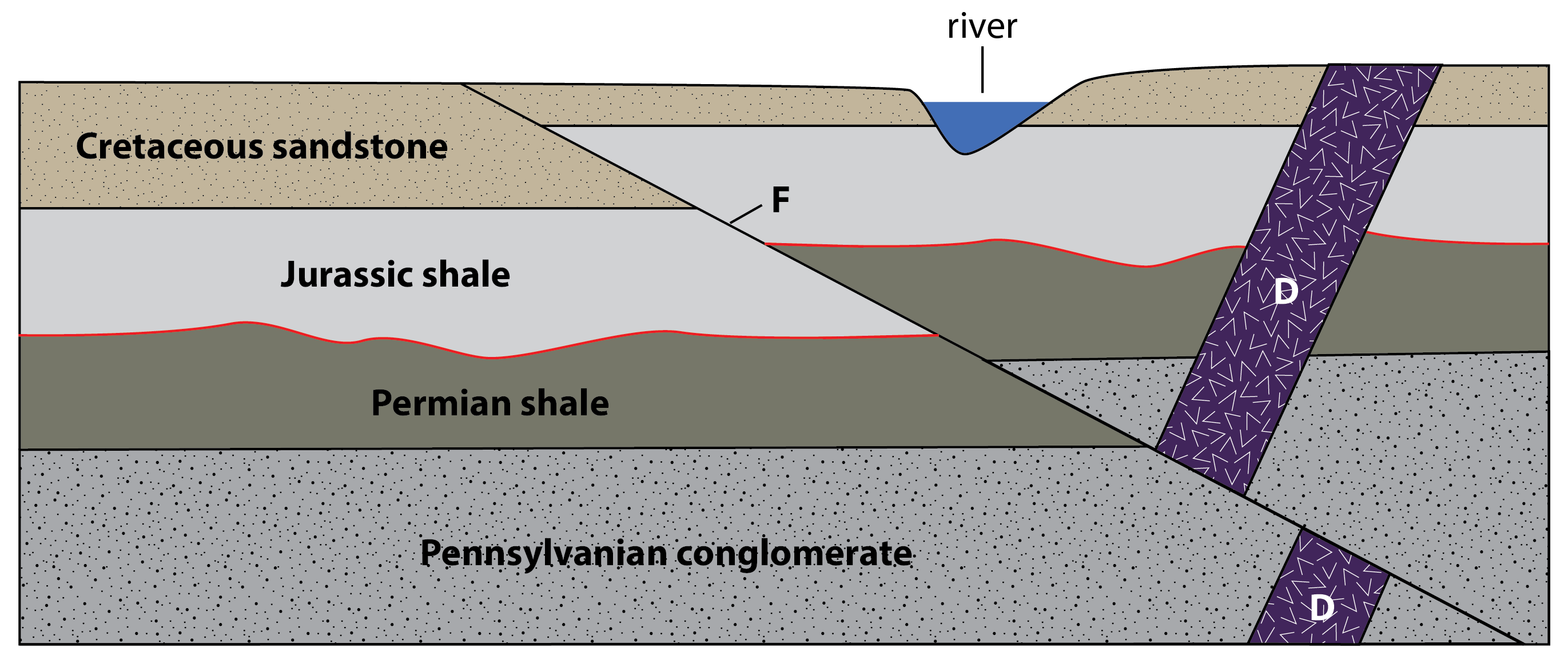
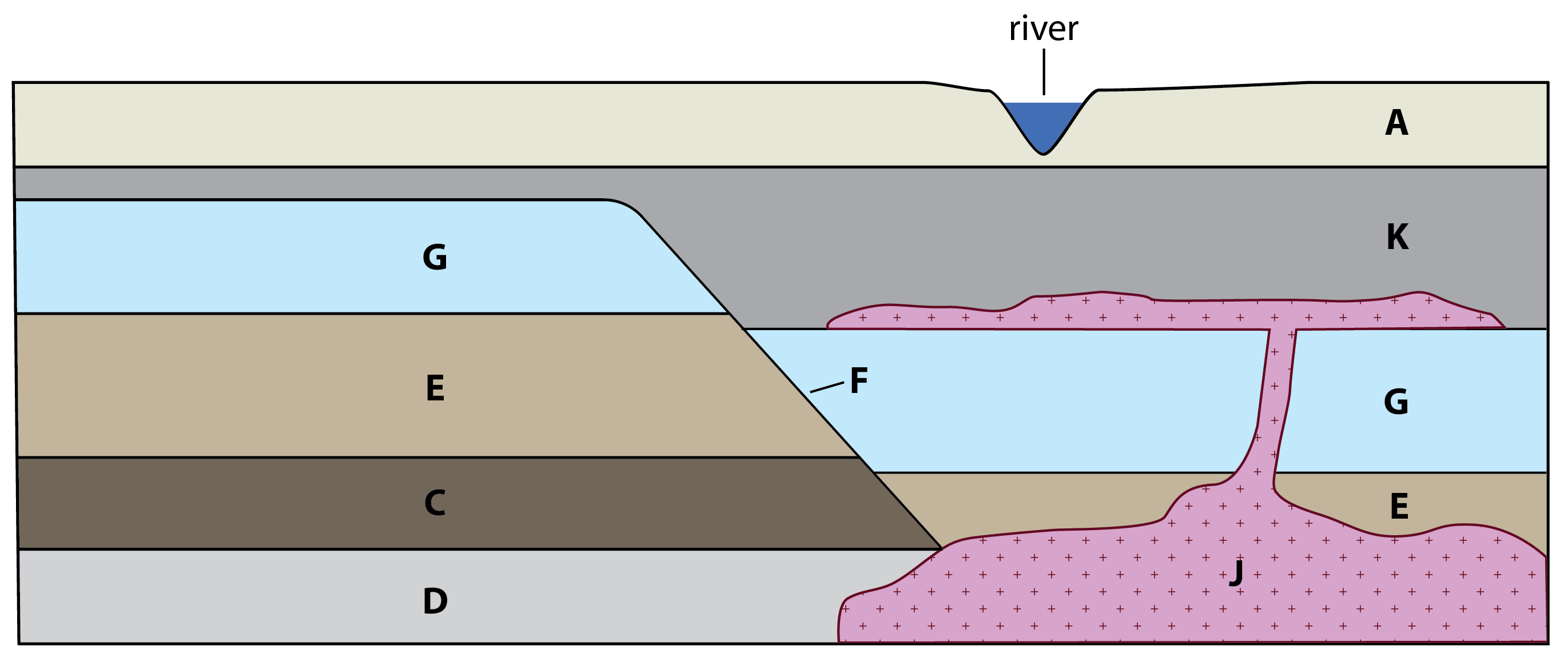
7. In the space below, write a short paragraph (<150 words) describing the geologic history for Figure D using complete sentences. To describe the sequence of sedimentary rocks, you may want to use the term “overlain”, as in “the Pennsylvanian conglomerate is overlain by the Permian shale”, or as an adjective, “the overlying Permian shale”. Unit D is a basalt dyke (a type of igneous intrusion), and the line labeled as F is a fault. Read more about faulting in section 10.3.
8. Write a point-form geologic history for Figure E in the table below. Specify which stratigraphic principle(s) you used to justify the position of each event in the timeline. Unit J is a granite pluton and sill (two types of igneous intrusion), and the line labeled as F is a fault. Read more about faulting in section 10.3.
| Youngest Event | Geologic History of Figure E | Justification |
|
|
|
|
|
|
|
|
|
|
|
|
|
|
|
|
|
|
|
|
|
|
|
|
|
|
|
|
|
|
|
|
| Oldest Event |
|
|
9. Write a point-form geologic history for Figure F in the table below. Specify which stratigraphic principle(s) you used to justify the position of each event in the timeline. If there are any unconformities present, identify which type and briefly describe what the unconformity represents. Unit L represents a rhyolite dome formed by felsic lava. Letter A refers to the surface denoted by the red line. Letter F represents a fault plane. All other letters refer to sedimentary rocks. Note that units B, C, and D have been folded into anticlines and synclines. Read more about folds in section 10.2.

| Youngest Event | Geologic History of Figure F | Justification |
|
|
|
|
|
|
|
|
|
|
|
|
|
|
|
|
|
|
|
|
|
|
|
|
|
|
|
|
|
|
|
|
|
|
|
|
| Oldest Event |
|
|
Media Attributions
- Figures A, C, D, E, F: © Siobhan McGoldrick. CC BY.
- Figure B: © Siobhan McGoldrick. Adapted after Figure 3.5.2 © Steven Earle. CC BY.
a written description of the timeline of geological processes responsible for the sequence of rocks in an area
a cubic or rectangular model used for study purposes to display geology in three-dimensions
a boundary in rock or sediment along which displacement has taken place
an upward fold where the beds are known not to be overturned
a downward fold where the beds are known not to be overturned
