
9.3 Estimating Dip Direction from a Geological Map
You have now observed how topography and geology interact to produce the patterns on a geological map. There are a few rules of thumb to help you interpret the attitude of the strata on a geological map based on the map patterns you observe.
Horizontal strata: contacts between horizontal strata follow the topographic contours (as in Figure 9.2.1).
Vertical strata: contacts between vertical strata are not deflected or influenced by topographic contours. These contacts often appear to cut topographic contours at a high angle.
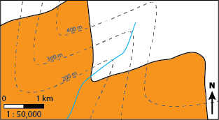
Dipping strata: contacts between dipping strata are deflected or bent by topographic contours (as in Figure 9.3.1). This deflection can help us determine the dip direction of a mapped unit simply by examining its map pattern, using the Rule of V’s.
The Rule of V’s is a visual, qualitative method to determine dip direction by examining the map pattern of the contact between two dipping units as it crosses a stream or a valley. There are a few select instances where the following does not hold true, but as a general guideline: a dipping contact forms a “V” shape as it crosses a stream or valley, and the point of the “V” points in the direction of dip. For example, the map in Figure 9.3.1 shows two units, one white and the other orange. The black line is the mapped contact between the two units. Notice how the contact makes a “V” shape as it crosses the stream (blue line). The “V” points towards the southwest because the contact is dipping towards the southwest.
Important: The Rule of V’s is used to describe the deflection of dipping geological contacts as they cross a stream – it is not used to describe the behaviour of topographic contour lines!
Examples
To better understand the Rule of V’s, it is helpful to visualize the geology in three-dimensions. The University of Leeds has developed an excellent, interactive tool to examine the Rule of V’s in a virtual landscape. As you examine the virtual landscape on the University of Leeds website, think about the following questions:
- How does changing the dip change the map pattern?
- How can you distinguish horizontal or shallowly dipping strata from vertical or steeply dipping strata in map view?
Remember, unlike the examples in Figure 9.2.1, in this case the topography remains fixed and the map pattern is changing in response to variations in the attitude of the geology (variations in the dip of the strata).
Media Attributions
- Figure 9.3.1: © Siobhan McGoldrick. CC BY.
a general rule for determining dip direction of dipping planar contacts deflected or bent as they cross a valley or stream
