
Rise of the Machines
The threats facing biodiversity underwent a fundamental shift in the twentieth century. Whereas wildlife declines in the nineteenth century generally involved someone setting a trap or firing a gun, the declines of the twentieth century were mainly the result of widespread habitat degradation from agricultural expansion and industrial development. The rapid growth and intensification of the resource sector was the result of several interacting factors:
- Mechanization. The farmers and lumberjacks of earlier periods had only muscle power and hand tools with which to push back the frontier, limiting the rate of change. The story of the twentieth century is one of increasing mechanization—more machines doing more things, with more efficiency, and more power.
- Energy. The increase in mechanization and expansion of the development frontier was supported by and dependent on an ever-increasing supply of easily transportable energy, primarily in the form of diesel and gasoline.
- Access. A defining feature of the twentieth century was the development of an extensive national transportation network that not only linked together Canada’s far-flung settlements, but also provided the access needed to bring resources from remote areas to market (Fig. 2.4).
- Innovation. Technological advancement was rapid in the twentieth century, leading to greater effectiveness in finding and exploiting resources as well as increased profitability.
- Population size. Canada’s population increased steadily over the twentieth century, increasing the demand for resources and providing the labour needed to extract them.
- Export market. During the twentieth century, Canada became one of the world’s leading exporters of resource staples, especially to the rapidly growing US market. Market demand was, in turn, a strong driver of development and technological innovation.
Resource development also led to the establishment of mining and mill towns in remote areas that owed their prosperity and survival to the extraction of a single resource. In time, these towns would become a politically powerful constituency that supported industrial development.
Agriculture
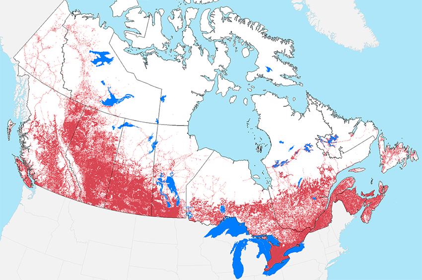
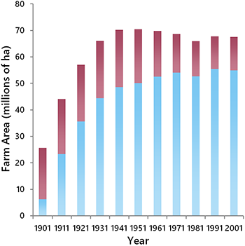
The amount of land used for agricultural production reached its peak in the 1930s (Figs. 2.5 and 2.6). Most of the agricultural expansion occurred in western Canada, and the three Prairie provinces today account for over 80% of Canada’s agricultural land. In the East, agriculture remained focused in the Great Lakes Lowlands and the lands adjacent to the St. Lawrence River.
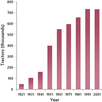
Although the amount of land devoted to agriculture plateaued early in the twentieth century, the impacts of agriculture on biodiversity continued to rise in later decades because of intensification. The transition from horses to tractors was pivotal. Steam tractors were already available at the turn of the century but widespread ownership of tractors did not occur until affordable gas-powered models became available in the 1940s (Fig. 2.7). Over the years, farms increased in size, through consolidation, and tractors grew larger to match. Whereas the popular 1937 Allis Chalmers Model B produced less than 20 horsepower, John Deere now sells eight-wheel behemoths that produce 620 horsepower and weigh more than 20 tonnes.
 |
 |
As farms mechanized, the cost of farming increased, leading to further intensification. Less and less of the landscape remained in a natural state. In addition, wetlands were drained to provide more cropland and to reduce the nuisance they represented to large farm machinery. It is estimated that more than 40% of prairie wetlands were lost to drainage over the past century and there is little evidence to suggest that the rate of loss has slowed in recent years (Cortus et al. 2011). Other manifestations of intensification included the removal of hedgerows, especially in Eastern Canada, and a progressive increase in the use of fertilizers, herbicides, and pesticides.
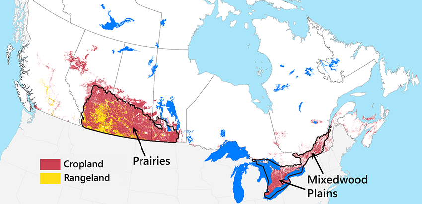
The rangelands of southeast Alberta and southwest Saskatchewan (Fig. 2.5) merit special mention because they followed a different trajectory. Low moisture inputs in these areas made them unsuitable for growing crops or pasture grass, so the native prairie remained largely intact. However, the replacement of bison with cattle, the control of prairie fires, and invasion by agronomic grasses had cascading effects on the integrity of these ecosystems (Fuhlendorf and Engle 2001). This region was also impacted by the development of an extensive road network.
Forestry
Rail networks expanded rapidly in the early decades of the twentieth century, providing access to a progressively larger proportion of Canada’s merchantable forest. Another important change in this period was the rise of the pulp and paper industry, particularly in Eastern Canada (Kerr et al. 1990). Advancements in the design of the rotary press allowed the production of large numbers of daily papers, which became popular throughout North America. Demand for newspapers was also stoked by rising population levels.
Harvesting for pulpwood led to changes in forestry practices. Previously, trees were individually selected based on their suitability for producing dimensional lumber, which meant that much of a forest stand remained after harvesting. With pulpwood harvest, smaller trees could be utilized and so could species not suited for lumber production. Therefore, harvesting became more intensive and involved a greater range of stand types (Drushka 2003).
The next major change in forestry was mechanization, which became widespread after World War II. Most important was the internal combustion engine, which powered everything from chainsaws to large logging trucks. Trucks offered much greater mobility and flexibility than trains, and consequently, the development frontier was pushed even deeper into Canada’s hinterland.
Mechanization also led to a further intensification of forest harvesting, culminating in the clearcut approach, which became the dominant method of harvesting in the last half of the twentieth century. Clearcutting offered several advantages for timber companies (Nyland 1996). First, it was efficient to implement, especially once harvesting was done with large machinery instead of chainsaws. Clearcutting also provided companies greater control over regeneration trajectories. Monocultures of desired species could be generated, boosting timber yields relative to natural regeneration, especially in mixedwood systems. The regenerating clearcuts were also even-aged, which facilitated the achievement of an even flow of timber each year at a standardized age at harvest (i.e., the rotation age).
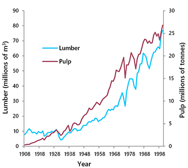
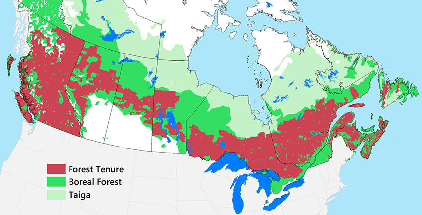
The combination of mechanization and improved access led to steadily rising production of both lumber and pulp over the twentieth century (Fig. 2.8). The majority of Canada’s merchantable forest is now subject to harvesting, and the remaining unallocated forest is mostly in the far north where productivity is low (Fig. 2.9). Harvesting has resulted in a progressive simplification of forest structures and patterns over time, and these changes continue to accumulate (see Chapter 5). Furthermore, forestry access roads have fragmented forested landscapes and served as wicks, drawing in other industrial and recreational users and their associated ecological impacts (Trombulak and Frissell 2000).
Oil and Gas
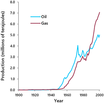
Oil and natural gas (Fig. 2.10) were discovered in Canada in the nineteenth century. However, significant levels of production did not occur until the middle of the twentieth century, when several factors came into alignment. The first factor was demand, which increased exponentially once the internal combustion engine came into widespread use. The second was exploration success, which improved as a result of systematic seismic surveys and better understanding of subsurface geology. The third was the ability to extract and ship the oil and gas to market, which improved with better technology and expanding infrastructure.
Oil and gas deposits were eventually found throughout the Western Canadian Sedimentary Basin, stretching from northeast BC, across most of Alberta, and into southern Saskatchewan. Additional deposits were found in the Maritimes, Northwest Territories, and offshore. Drilling and infrastructure development were initially centred in the Prairie region, where most of the early discoveries were made and where access was plentiful. However, by the 1960s, road and pipeline networks were being developed deep into the boreal forest and the foothills of the Rocky Mountains. In areas of active oil and gas development, the annual rate of forest clearing for roads, well sites, pipelines, and seismic exploration approached the rate of cutting by the forestry sector (ECA 1979).
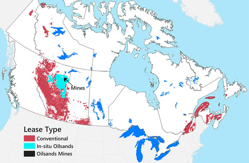
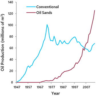
In 1973, the production of conventional oil reached its peak and then began to slowly decline (Figs. 2.11–2.12). Thereafter, growth in oil production was achieved through the development of unconventional deposits. Most important were the oil sands in northern Alberta, which contained thick bitumen mixed with sand. Some of the oil sands deposits were close enough to the surface to be recovered through surface mining, and this is where initial production began, in 1967. In the 1990s, technology was developed that allowed the recovery of deeper oil sands deposits using steam heating and in situ extraction. As a result, the land area affected by oil sands development expanded from 4,800 km2 (surface mining only) to 142,000 km2 (Fig. 2.10). Today, the oil sands produce more oil than all other sources in Canada combined (Fig. 2.12).
 |
 |
Not all of Canada’s oil and gas deposits have been brought into production. Many deposits remain stranded because of a lack of infrastructure and challenging working conditions, especially in the Northwest Territories. In areas with established infrastructure, there has been a tendency for successive waves of development to occur, as evolving technologies allowed different types of deposits to be profitably extracted.
The development of oil and gas over the last century has left a significant cumulative footprint, especially in the western boreal forest. Over 400,000 wells were completed in Canada between 1955 and 2017 (CAPP 2017), disturbing approximately 1 ha of habitat in each case. Virtually all of these wells required the construction of an access road, and most were connected to a pipeline. In addition, hundreds of thousands of kilometres of seismic cut-lines remain in forested areas as a legacy of exploration activities. Oil and gas development and refinement also resulted in air, soil, and water pollution (see Chapter 5).
Mining
Before 1900, mining in Canada was limited to small-scale operations focusing mainly on coal, iron, and gold (Cranstone 2002). Mining slowly expanded in the early twentieth century, closely tied to the expansion of transportation infrastructure. Many mining towns in the Canadian Shield and BC interior got their start during this early period, including Kimberley, Flin Flon, Sudbury, and Val-d’Or.

The demand for metals and other minerals rose rapidly after World War II as a result of increased mechanization. Demand was further stimulated by advances in metallurgy, which led to new applications for metals. Rising demand provided mining companies with the incentive and security needed to undertake large, capital-intensive mining projects. Moreover, with the advent of heavy machinery, it became possible to remove large quantities of surface material to access extensive low-grade deposits through open-pit mining. Finally, advancements in science and technology enabled systematic exploration for mineral deposits and provided better methods of ore refinement. Consequently, mining production increased rapidly in the second half of the twentieth century (Fig. 2.13).
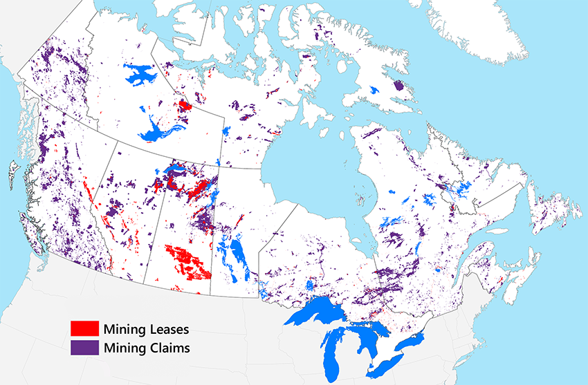
Today, there are 220 principal mines in Canada producing more than 60 minerals and metals (NRCAN 2013). These mines are distributed across the entire country, including the territories (Fig. 2.14).
From an ecological perspective, the most important legacy of mining in the twentieth century is the waste produced. Hundreds of millions of tonnes of rock had to be crushed, ground, and then chemically processed to extract the target minerals, which were generally a minor component of the ore (less than 1% for many metals). The residual tailings were stored on-site or discharged into the water, posing a variety of environmental hazards (Allan 1997).
Ontario’s Sudbury region provides one of the more egregious examples of environmental harm caused by mining in the twentieth century. Over 7,000 lakes within a 17,000 km2 area were acidified to the point of significant biological damage (Keller et al. 2007). In addition, the lakes and soils in the Sudbury region accumulated dangerously high levels of copper, nickel, zinc, and lead from windblown dust from tailings piles (Nriagu et al. 1998). The result was “an unusual anthropogenic ecosystem of denuded barren land with lifeless lakes” (Nriagu et al., 1998, p. 99).
Not all mining operations were as bad as Sudbury’s, but it was not alone in leaving a long-lasting environmental legacy. Over 10,000 abandoned mines exist in Canada (MacKasey 2000), many of which are leaching arsenic, mercury, lead, sulfuric acid and other chemicals into the environment (Parsons 2007). Consequently, twentieth-century mining continues to have an environmental impact today that extends well beyond the footprint of the mines themselves.
