
Case Study 2: Land‐Use Planning
Background
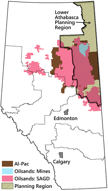
This case study traces the development of the 2012 Lower Athabasca Regional Plan in northeast Alberta (Fig. 11.6; GOA 2012). Through this case study, we will explore the management of cumulative effects and the mechanics of government-led regional land-use planning.
The path that led to the Lower Athabasca Regional Plan began in the late 1990s with growing discontent over the government’s laissez-faire approach to land management in the face of rising development pressures (Kennett 2002; Brownsey and Rayner 2009). Conflicts among land users were increasing and were not being resolved. There was also a perception that the government had abdicated its responsibility for the sound stewardship of public lands, as evidenced by the increasing degradation of Alberta’s landscapes.
A key factor was the oil boom that began in the late 1990s, taking oil from under $20 a barrel in 1998 to over $100 a barrel in 2008. This rise in oil prices coincided with the first commercial application of steam-assisted gravity drainage (SAGD), a new extraction technique that enabled the recovery of deeply buried oil sands deposits. With this new technique, oil sands extraction became viable across ~140,000 km2 of northern Alberta—an area almost the size of Florida—instead of the much smaller surface-mineable zone (Fig. 11.6).
Issues do not advance without advocates, and in this case, a network of conservation practitioners from several different organizations played a central role in propelling land-use concerns onto the political agenda. The organizations included the ALCES group (a consultancy), Al-Pac, the Canadian Institute of Resources Law, the Edmonton chapter of the Canadian Parks and Wilderness Society, and the University of Alberta.
Collectively, this network helped to characterize the problem, devise solutions, and build support for change. Presentations that told the story of landscape change in Alberta—past, present, and future—were made to government officials and a wide variety of stakeholders, making the case for land-use planning. Members of the network also advanced ideas concerning the ecological, institutional, and operational aspects of managing cumulative effects (Kennett 1999; Schneider 2002; Weber and Adamowicz 2002).
Industry was also engaged, partly because conflicts between companies working on the same land base had to be resolved, and partly because of growing concerns about social licence. Leadership was provided by the Alberta Chamber of Resources, a cross-sector industry association. In 2000, the Chamber initiated a provincial integrated landscape management program that involved industry education, a series of pilot projects (similar to the Gulf Surmont project discussed in the previous case study), and a research chair at the University of Alberta (Demulder and Thorp 2007). Another notable development was the establishment, in 2000, of the Cumulative Environmental Management Association—a stakeholder forum for advancing the management of cumulative effects in the oil sands region funded mainly by industry.
The environmental community was just beginning to shift its focus from forestry to the oil and gas sector during the period of this case study. Their nascent efforts, which would later take the form of anti-pipeline protests, also provided impetus for addressing land stewardship concerns.
The Alberta Land-Use Framework
The initial government response to the growing concerns over land use took place within a single department: Alberta Environment. It established a new Integrated Resource Management Division in 2000, with a mandate to develop regional management plans. This effort proved to be unsuccessful, mainly because rivalries among government departments stymied progress (Brownsey and Rayner 2009). It became clear that integrated regional planning could not occur on the ground until the government itself became more integrated. This would require major changes in institutional structure, policy, and ultimately, political leadership (Kennett 2002).
The next attempt at integrated land management began in 2006, with the election of Ed Stelmach as premier. Stelmach named Ted Morton, a senior politician, as Minister of Sustainable Resource Development and charged him with developing a comprehensive framework for managing land use across the province. Integrated planning now had champions at the highest levels and could make headway against sectoral resistance. The resulting Land-Use Framework was released in late 2008 and incorporated input from several issue-specific working groups and extensive public consultation (GOA 2008). In 2009, the government passed the Alberta Land Stewardship Act, to provide a legal foundation for the Framework.
The Land-Use Framework outlined a new overarching approach for land management in the province. It explicitly acknowledged the land’s finite capacity and the need for government leadership in coordinating development. The stated purpose was to manage growth in a way that would balance economic, environmental, and social goals (GOA 2008). Under the Land-Use Framework, the government would:
- Divide the province into seven regions (Fig. 11.6) and develop land-use plans for each. These plans would integrate provincial policies at the regional level, set out regional land-use objectives, and provide the context for land-use decision making within the region.
- Create a Land-Use Secretariat to lead the development of regional plans in conjunction with relevant departments.
- Implement cumulative effects management at the regional level.
- Establish an information, monitoring, and knowledge system.
- Include Indigenous peoples in land-use planning.
Of particular relevance to the conservation of biodiversity was the explicit commitment to manage cumulative effects. The Land-Use Framework required regional plans to define limits on the effects of development on the air, land, water and biodiversity of the region (GOA 2008). Within these limits, industry would be encouraged to innovate in order to maximize economic opportunity.
The Lower Athabasca Regional Plan
The first plan to be developed under the Land-Use Framework was the Lower Athabasca Regional Plan, in the heart of the oil sands region (Fig. 11.6; GOA 2012). Planning got underway in 2009 and was completed in 2012. The plan adhered to the direction provided by the Land-Use Framework and also incorporated concepts and strategies from earlier planning efforts by the Cumulative Environmental Management Association (the local oil sands stakeholder forum). Input from a regional advisory committee and the general public was also incorporated.
The Lower Athabasca Regional Plan defined seven regional outcomes and a set of strategies for achieving those outcomes (GOA 2012). The third outcome pertained specifically to conservation: “Landscapes are managed to maintain ecosystem function and biodiversity” (GOA 2012, p. 42). Most of the strategies in the plan were directives for further planning. For example, the plan specified that air, water, and biodiversity would be managed through a set of management frameworks that set targets for selected indicators and established triggers for proactive intervention. In addition, biodiversity objectives would be advanced by establishing new protected areas. We will examine the main biodiversity-related strategies in turn.
Protected Areas
The impetus for including new protected areas in the Lower Athabasca Region Plan can be traced to the Terrestrial Ecosystem Management Framework, developed by the Cumulative Environmental Management Association in 2008 (CEMA 2008), and before that, to a protected area campaign launched by the Canadian Parks and Wilderness Society in 2001. The additional protected areas were meant to fill gaps in ecosystem representation and to provide a better regional balance between industrial development and habitat protection. The Cumulative Environmental Management Association’s consensus recommendation was that protected areas should comprise 20–40% of the region (CEMA 2008).
The main task for the Land-Use Secretariat was deciding where the new parks should go. To aid its decision, the Secretariat commissioned a study by a group of researchers at the University of Alberta. The research group used the Marxan program (see Chapter 8) to identify reserve designs that achieved coarse-filter ecosystem representation while accounting for the contributions of existing protected areas (Schneider et al. 2011). The coarse-filter elements were derived from the provincial ecosystem classification system and a provincial vegetation inventory (NRC 2006). Preference was given to planning units with the lowest resource value and the lowest level of industrial footprint. Various permutations of reserve design objectives were explored (e.g., different levels of representation and different levels of reserve clumping).
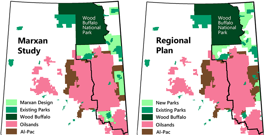
The Land-Use Secretariat did not solicit public input about the protection options, and no public record exists for how the decision was made. The final configuration was broadly similar to a design submitted by the research group that used a 20% representation target and maximal clumping (i.e., 20% of each ecosystem type and each vegetation type had to be represented in a system of large contiguous reserves; Fig. 11.7). This was consistent with the low end of the Cumulative Environmental Management Association’s protection target.
To be sure, the general configuration of the optimal reserve design was fairly obvious from the start. To avoid the high economic impact of curtailing oil sands development, new reserves had to be directed to the northern half of the planning region and along the Saskatchewan border. Another logical step was to use new reserves to connect Wood Buffalo National Park to nearby protected areas in a hub and spoke design (Fig. 11.7). The main contribution of the Marxan analysis was to demonstrate that such a design was capable of meeting ecosystem representation targets.
The reason Marxan was able to avoid selecting planning units within the oil sands region was that the surrounding landscapes were similar enough to be substitutable. This result hinged on the coarseness of the representation targets, which included only ecosystem type and major vegetation type. A finer-scale analysis would likely have uncovered features within the oil sands zone that are not found elsewhere.
The reaction of the resource industry to the new protected areas was mixed. Although existing oil leases were largely avoided, a few small companies were affected, and they were very vocal in their opposition. Most other companies understood the strategic value of establishing these new protected areas and were supportive.
As for the conservation value of the new sites, there are two perspectives. One is that the new reserve system is a major conservation achievement. A total of 13,600 km2 of new protected areas were added to the existing system, bringing the level of protection within the Lower Athabasca Region to 21%. Combined with Wood Buffalo National Park (which lies just outside of the Lower Athabasca Region), these reserves constitute the world’s largest contiguous boreal protected area, covering more than 67,000 km2 (GOA 2018a).
A more critical perspective is that the newly protected lands contain almost no petroleum deposits, and so were never under substantive threat. Thus, there is no real conservation gain.
The reality is somewhere between these two views. While petroleum extraction is not a significant threat within the new protected areas, the sites do have potential for forestry and there have also been rising impacts from all-terrain vehicle use. Furthermore, experience suggests that new threats often emerge over time. For example, while mining is currently not an issue in the region, new diamond mining operations have started north of Wood Buffalo National Park.
Surface Water Quantity Management Framework
The Lower Athabasca Regional Plan called for the development of management frameworks for air, water, and biodiversity. In this section, we will examine the Surface Water Quantity Management Framework (henceforth the Water Framework), released in 2015. It provides a good example of the structured decision-making process in action (GOA 2015).
In this case, rather than conducting the planning process internally, the government enlisted the support of the Cumulative Environmental Management Association. A multi-stakeholder planning committee was established, and this is where most of the planning took place.
The scope of the Water Framework was restricted to the management of water quantity, and a separate framework was developed for managing water quality. Both frameworks focused specifically on the lower Athabasca River, the main waterway in the region. Narrowing the scope in this way made the planning processes tractable; however, it meant that water management across the broader region was not addressed. To date, no water management framework for the full watershed has been developed.
The objective of the Water Framework was to manage cumulative water withdrawals “to support human and ecosystem needs, considering an acceptable balance between social, environmental, and economic interests” (GOA 2015, p. 23). Clarity was brought to this broad objective by selecting indicators for three sub-objectives. For the economic dimension, the primary indicator was the volume of water available to oil sands companies for mining operations. For the environmental dimension, the primary indicator was habitat quality for fish. And for the social dimension, the primary indicator was river navigability for Indigenous communities during low-flow periods.
A hydrological model was developed by a technical team to help the planning committee explore trade-offs among the sub-objectives. The model predicted water flows under alternative management approaches while taking climate change into account. The committee iteratively refined management alternatives based on what they learned about trade-offs (Gregory et al. 2012, p. 232).
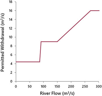
An important decision was to link the rate of permitted withdrawal to the rate of river flow (Fig. 11.8). This way, oil sands companies could store water on-site when it was plentiful, providing them with flexibility during low-flow periods. The committee was able to achieve consensus on limits for most flow scenarios, with the notable exception of 1-in-100-year low-flow events (which is when the trade-offs among desired outcomes were greatest). In this case, the government set the limit through an internal decision.
The Biodiversity Management Framework
The Biodiversity Management Framework (henceforth the Biodiversity Framework) was due to be completed in 2013 but as of this writing (early 2023), it has still not been released. The description provided here is from a draft that was informally circulated in 2014.
In contrast to the Water Framework, planning for the Biodiversity Framework did not involve a stakeholder planning committee, even though the Cumulative Environmental Management Association had an active ecosystem working group and had released an ecosystem management framework of its own in 2008 (CEMA 2008). Instead, planning was done internally, through an interdepartmental planning team.
The Biodiversity Framework emphasized the broad goals of sustaining biodiversity and ecosystem health, carried over from higher-level plans. However, the specific meaning of “sustain” and “health” was not defined. Additional objectives included recovering species at risk, preventing new species from becoming endangered, and providing hunting and fishing opportunities for Indigenous communities.
It was not feasible to work with all species individually, so the planners devised a set of indicators that were meant to serve as biodiversity proxies. Four categories of indicators were identified: terrestrial habitat, aquatic habitat, terrestrial species, and aquatic species. For each category, a composite indicator was selected to represent the general state of biodiversity, and two indicators were selected to reflect specific biodiversity challenges in the region (Table 11.2). Additional indicators were used to provide supporting information, but they did not trigger management responses.
Table 11.2. Biodiversity indicators used in the draft Biodiversity Framework.
|
Category
|
Indicator |
| Terrestrial Habitat | Percent of upland area free of human footprint |
| Amount of old-growth forest | |
| Percent of upland area that is at least 50 m from human footprint | |
| Aquatic Habitat | Percent of wetland area free of human footprint |
| Amount of undisturbed fen cover | |
| Stream connectivity | |
| Terrestrial Biodiversity | Terrestrial biodiversity intactness index |
| Woodland caribou | |
| Non-native plants | |
| Aquatic Biodiversity | Aquatic biodiversity intactness index |
| Arctic grayling | |
| Walleye |
The use of a composite biodiversity index as a top-tier indicator is controversial. The benefit of using such an index is that it captures the status of the entire ecosystem in a single measure, which simplifies management. The drawback is that a composite measure may mask, through dilution, the very changes that conservation is intended to prevent. If the intent is to maintain biodiversity, then arguably, attention should be focused on the species most sensitive to disturbance (Devictor and Robert 2009). These are the weakest links in the chain.
In the Biodiversity Framework, each indicator was assigned an initial management response based on the level of risk it faced. Risk was determined by comparing the current status of an indicator with its reference state (i.e., its status when unaffected by human influences). Four levels of management response were defined, corresponding to increasing levels of risk:
1. Low risk: ongoing management
2. Moderate risk: improve knowledge and adjust management approaches as needed
3. Considerable risk: add new tools and shift from voluntary to mandatory requirements as needed
4. High risk: further increase in stringency, which could include restrictions on land disturbance and additional regulations
The management responses prescribed in this section of the Biodiversity Framework are too vague to be of any practical value—a major shortcoming. The only direction provided is that higher risk demands greater conservation action, which is self-evident. The question of what those actions should be is left unanswered. Nor does the Framework provide any insight into how trade-offs with resource development objectives should be resolved. The only clear decision the planning team made was to demote the concept of cumulative disturbance limits to an optional management tool.
The land disturbance plan that was meant to accompany the Biodiversity Framework also foundered and there is no indication of when it might be released. Without clear direction on biodiversity objectives, the planning team charged with developing the disturbance plan struggled to make progress. Momentum for disturbance planning at the regional scale was slowly lost, and the emphasis eventually shifted to meeting the habitat intactness requirements of woodland caribou (see Case Study 3).
Analysis and Conclusions
This case study illustrates both the promise and peril of regional planning. Regional planning is needed to address the root causes of many conservation problems, particularly those related to the cumulative effects of industrial development. However, its inherent complexity makes it difficult to achieve substantive progress.
In this example, the political momentum attained in the late 1990s for addressing cumulative industrial impacts led to a paradigm shift in provincial land-use policy. The “open frontier” mentality that characterized earlier periods was replaced with an understanding that landscapes have finite capacity and that trade-offs among land uses have to be formally addressed. There was also a formal commitment to balance economic objectives with environmental and social objectives.
The effects this policy shift had on land management were varied. The most important achievement, from a conservation perspective, was the establishment of 13,600 km2 of new protected areas. These reserves were intended to offset the impacts of development in the adjacent oil sands region. In addition, frameworks for managing regional air quality and water-related concerns in the Athabasca River were developed and adopted.
Much less progress was made in managing cumulative effects on the working landscape. Despite high-level policy commitments and more than 20 years of effort, no limit on disturbances has ever been implemented. As a result, the overall industrial footprint in the Lower Athabasca Region has steadily increased, despite the progress made through voluntary integration efforts (ABMI 2020).
Several factors contributed to the failure of the cumulative effects initiative. First, the scope of planning was not adequately contained. Instead of focusing on the management of cumulative effects, which it was originally intended to do, the Lower Athabasca Regional Plan became a catch-all for everything from economic diversification to providing recreational opportunities. This resulted in overwhelming complexity, superficial planning, and the eventual deferment of core planning issues (including cumulative effects) to secondary planning processes.
The initiative also struggled against internal government divisions and resistance to change, particularly from the proponents of economic development. Moreover, the governance system needed for integration at the regional scale was lacking. The emergence of Stelmach and Morton as champions for integrated planning provided a political window of opportunity for making substantive progress. However, this window did not remain open long enough for the required structural changes to occur.
Political factors were also important. A pivotal development was a disinformation campaign by the opposition Wild Rose Party, which turned the Land-Use Framework into a liability for the government instead of an asset. This campaign convinced many rural Albertans—a core constituency of the ruling Conservatives—that the government’s real intent was to weaken their property rights. The recession of 2008 was another contributing factor, resulting in changing political priorities. Finally, the initiative lost its political champions when Morton changed ministerial portfolios in 2010, and Stelmach resigned as premier in 2011.
In 2012, when planning efforts finally turned to the management of biodiversity and cumulative effects, political attention had shifted elsewhere. Without high-level direction and support, the biodiversity planning team was in no position to begin setting strict regional limits on disturbance or even to launch a stakeholder-based planning process to investigate the options. Instead, the team spent the next six years in planning limbo, trying to establish a direction and ultimately producing nothing more than a draft system of biodiversity indicators. The cumulative effects “can” was kicked further down the road.
In principle, the legislation underpinning the Land-Use Framework should have ensured that the planning process was completed as intended. However, as with much of the environmental legislation in Canada, the Alberta Land Stewardship Act is discretionary. It provides the legal basis to develop and enforce regional plans but contains no explicit requirements to do so (Bankes et al. 2014).
The Water Framework provides a useful contrast. A structured decision-making approach was used to identify objectives, explore trade-offs among management alternatives, and make a decision on withdrawal limits. Part of what made this possible was the decision to narrow the scope to a single river. Complexity could not have been similarly contained for land-based cumulative effects because industrial activities are widely dispersed. Nevertheless, there is nothing about land-based cumulative effects that makes them impossible to manage given sufficient focus and political will.
In summary, this case study illustrates the wide range of factors that can affect regional planning, making outcomes difficult to predict. The importance of the problem being addressed and the level of support and opposition for change are fundamental factors. Internal government champions can make a big difference, but they come and go and windows of opportunity open and close. Regional planning may also become politicized, as evidenced by the Wild Rose Party’s attack. Complexity is a major problem and can lead to delay and superficial planning. Finally, institutional barriers to integration pose a significant challenge. As a general rule, the greater the level of complexity or desired change, the higher the level of support and political momentum required.
