
Appendix 2: Answers to Practice Exercises
The following are suggested answers to the practice exercises embedded in the various chapters of A Practical Guide to Introductory Geology. Answers to the questions in each lab exercise are provided in Appendix 3.
Google Earth Tutorial
Try typing these coordinates into the search bar in Google Earth. What geographic feature is located at 51°02’39” N 114°03’47” W? Answer: Calgary Tower.
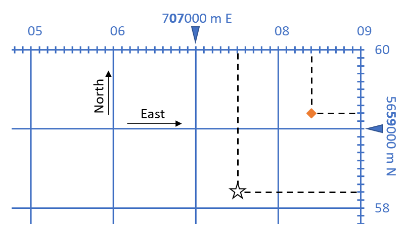
- What are the UTM coordinates (easting and northing) of the point in Figure T12 b? Answer: (orange diamond) 11 U 708400 m E 5659200 m N.
- Try plotting the coordinate 11 U 707500 m E 5658200 m N on Figure T12 b. Answer: see star on diagram below.
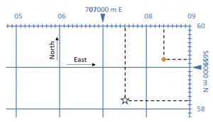
- In the UTM grid shown in Figure T12 b, what is the length in metres of each side of each square on the grid? Answer: 1000 m or 1 km grid.
- To see the grid lines for each system in Google Earth, click on View, Grid. Try zooming in and out to see how each grid type looks. Try this using the geographic grid (lat/long) and the UTM grid.
- Type “Mount Royal University” into the search bar and click Search. Hover your cursor right on the place marker. What are the coordinates for MRU in lat/long? Remember, you must specify that MRU is north of the equator and west of the prime meridian! Answer: approximately 51° 00’41″N 114° 07’52″W.
- What are the coordinates for MRU in UTM coordinates? Remember, you must specify the zone number! Answer: approximately 11 U 701228 m E 5655021 m N.
- What are the coordinates for MRU in UTM as a grid reference? Remember, you must specify the zone number! Answer: 11 U 012550.
Introduction
Practice Exercise: Using geological time notation
- 2.75 ka is 2,750 years.
- 0.93 Ga is 930,000,000 years or 930 million years.
- 14.2 Ma is 14,200,000 years or 14.2 million years.
Practice Exercise: Take a trip through geological time
- The oxygenation of the atmosphere started at around 2.5 Ga (2500 Ma). It was a catastrophe for many organisms because they could not survive the strong oxidizing effects of free oxygen.
- We don’t really know the answer to this, but it’s not very long if you include insects, and there is evidence of insect damage to some of the earliest plants.
- Plants on land allowed for animals on land, so without land plants, we wouldn’t be here.
Lab 1: Plate Tectonics
Practice Exercise 1.1 Volcanoes and the rate of plate motion
![Pacific Plate rates of motion [SE]](https://opentextbc.ca/physicalgeologyearle/wp-content/uploads/sites/145/2016/07/ex10-2.png)
Lab 2: Mineral Properties and Non-Silicate Minerals
Practice Exercise 2.1
Amethyst (SiO2), halite (NaCl), and (surprisingly) ice (H2O) are all minerals. Although sugar is a naturally occurring solid, it is an organic compound and therefore is not a mineral. Cubic zirconia (ZrO2) is not a mineral because it is synthetically produced to be used as a gemstone, as it closely resembles diamonds. Obsidian is a naturally occurring volcanic glass. Like all glasses, obsidian does not have an orderly crystalline structure and is therefore not a mineral.
Practice Exercise 2.2
| Name | Formula | Group |
|---|---|---|
| sphalerite | ZnS | sulphide |
| magnetite | Fe3O4 | oxide |
| pyroxene | MgSiO3 | silicate |
| anglesite | PbSO4 | sulphate |
| sylvite | KCl | halide |
| silver | Ag | native |
| fluorite | CaF2 | halide |
| ilmenite | FeTiO3 | oxide |
| siderite | FeCO3 | carbonate |
| feldspar | KAlSi3O8 | silicate |
| sulphur | S | native |
| xenotime | YPO4 | phosphate |
Practice Exercise 2.3
Responses will vary.
Practice Exercise 2.4
| Element | Silicon | Calcium | Sodium | Potassium | Magnesium |
|---|---|---|---|---|---|
| Source(s) | quartz sand | lime-stone | halite (NaCl) | sylvite (KCl) | dolomite ((Ca,Mg)CO3), magnesite (MgCO3), salt lakes and the ocean |
Lab 3: Silicate Minerals
Practice Exercise 3.1 Ferromagnesian silicates
| Mineral | Formula | Ferromagnesian Silicate? |
|---|---|---|
| olivine | (Mg,Fe)2SiO4 | yes |
| pyrite | FeS2 | no (it’s a sulphide, not a silicate) |
| plagioclase | CaAl2Si2O8 | no |
| pyroxene | MgSiO3 | yes |
| hematite | Fe2O3 | no (it’s an oxide, not a silicate) |
| orthoclase | KAlSi3O8 | no |
| quartz | SiO2 | no |
Lab 4: Igneous Rocks
Practice Exercise 4.1 Rock types based on magma composition
| Rock Sample | SiO2 | Al2O3 | FeO | CaO | MgO | Na2O | K2O | What type of magma is it? |
|---|---|---|---|---|---|---|---|---|
| Rock 1 | 55% | 17% | 5% | 6% | 3% | 4% | 3% | intermediate (although the SiO2 level is borderline, there is too little FeO, MgO and CaO to be mafic) |
| Rock 2 | 74% | 14% | 3% | 3% | 0.5% | 5% | 4% | felsic |
| Rock 3 | 47% | 14% | 8% | 10% | 8% | 1% | 2% | mafic |
| Rock 4 | 65% | 14% | 4% | 5% | 4% | 3% | 3% | intermediate (although the SiO2 level is borderline, there is too much MgO and CaO to be felsic) |
Practice Exercise 4.2 Porphyritic minerals
- only olivine phenocrysts
- pyroxene and amphibole phenocrysts, along with plagioclase with a composition that is about half-way between the Ca-rich and the Na-rich end-members.
Practice Exercise 4.3 Mineral proportions in igneous rocks
- Roughly 25% K-feldspar, 30% quartz, 35% albitic plagioclase and 10 biotite/amphibole,
- Roughly 65% plagioclase and 35% biotite/amphibole (most likely amphibole),
- Roughly 45% anorthitic plagioclase, 25% amphibole and 35% pyroxene
- Roughly 50% pyroxene and 50% olivine.
Practice Exercise 4.4 Proportions of Ferromagnesian Silicates
The approximate proportions are: 10%, 50%, 30% and 2%, and the corresponding rock names are granite, gabbro (although it’s right on the boundary between gabbro and diorite), diorite and granite.
Lab 5: Sediments and Sedimentary Rocks
Practice Exercise 5.1 Chemical weathering
| Chemical change | Process |
|---|---|
| 1. Pyrite to hematite | oxidation |
| 2. Calcite to calcium and bicarbonate ions | dissolution |
Practice Exercise 5.2 Describing the weathering origins of sands
| Sand description | Possible processes |
|---|---|
| Fragments of coral etc. from a shallow water area near to a reef in Belize | Reefs are constantly being eroded by ocean waves, and the fragments are washed inshore by currents and then further eroded by wave action. |
| Angular quartz and rock fragments from a glacial stream deposit near Osoyoos | Quartz-bearing rocks have been eroded and transported by a glacier. The fragments may have been moved a short distance by a stream, but not enough to produce rounding. |
| Rounded grains of olivine and volcanic glass from a beach in Hawaii | The olivine and glass grains are eroded by waves from volcanic rock and then thoroughly rounded by waves on the beach |
Practice Exercise 5.3 Classifying sandstones
| Description | Rock name |
|---|---|
| Angular grains, 85% quartz, 15% feldspar, less than 5% silt and clay | Arkosic arenite |
| Rounded grains, 99% quartz, less than 2% silt and clay | Quartz arenite |
| Angular grains, 70% quartz, 20% lithic and 10% feldspar, roughly 20% silt and clay | Lithic wacke |
Lab 6: Metamorphic Rocks and the Rock Cycle
Practice Exercise 6.1 How long did it take?
It might have taken in the order of 20 to 25 million years for these garnets to form, but even more time is needed than that to produce the rock because we have to account for the sedimentary process and then burial and lithification and then deeper burial to reach metamorphic environment – several tens of millions more years.
Practice Exercise 6.2 Metamorphic rocks in areas with higher geothermal gradients
| Metamorphic Rock Type | Depth (km) |
|---|---|
| 1. Slate | 2 to 5 |
| 2. Phyllite | 5 to 8 |
| 3. Schist | 8 to 12 |
| 4. Gneiss | 12 to 17 |
| 5. Migmatite | 17 to 25 |
Practice Exercise 6.3 Naming metamorphic rocks
| Rock Description | Name |
|---|---|
| 1. A rock with visible minerals of mica and with small crystals of andalusite. The mica crystals are consistently parallel to one another. | Schist or (preferably) Mica-andalusite schist |
| 2. A very hard rock with a granular appearance and a glassy lustre. There is no evidence of foliation. | Probably quartzite |
| 3. A fine-grained rock that splits into wavy sheets. The surfaces of the sheets have a sheen to them. | Phyllite |
| 4. A rock that is dominated by aligned crystals of amphibole. | Amphibolite |
Practice Exercise 6.4 Rock around the rock-cycle clock
Sedimentary rock is buried deeper to make metamorphic rock, the metamorphic rock is uplifted and during this process the material overhead is eroded so that it can be exposed at surface. The metamorphic rock is then eroded to make more sediments, which are transported by wind, water, or ice, deposited and then buried to make sedimentary rock. This would likely take at least 60 million years.
Lab 7: Relative Dating and Geological Time
Practice Exercise 7.1 Cross-cutting relationships
![Relative ages: 2: oldest: 3: middle, 1: youngest [SE]](https://openeducationalberta.ca/practicalgeology/wp-content/uploads/sites/66/2020/06/ex8-1-300x269-1.png)
Lab 8: Mapping Fluvial Landscapes
Practice Exercise 8.1 Understanding the Hjulström-Sundborg Diagram
![[SE]](https://opentextbc.ca/physicalgeologyearle/wp-content/uploads/sites/145/2016/07/ex13-3.png)
- A fine sand grain (0.1 millimetres) is resting on the bottom of a stream bed.
- What stream velocity will it take to get that sand grain into suspension? Roughly 20 centimetres per second.
- Once the particle is in suspension, the velocity starts to drop. At what velocity will it finally come back to rest on the stream bed? Roughly 1 centimetres per second.
- A stream is flowing at 10 centimetres per second (which means it takes 10 seconds to go 1 metre, and that’s pretty slow).
- What size of particles can be eroded at 10 centimetres per second? No particles, of any size, will be eroded at 10 centimetres per second, although particles smaller than 1 millimetre that are already in suspension will stay in suspension.
- What is the largest particle that, once already in suspension, will remain in suspension at 10 centimetres per second? A 1 millimetre diameter particle should remain in suspension at 10 centimetres per second.
Practice Exercise 8.2 Scale bar
What R.F. is shown by the scale bar drawn above? Assume that each of the long bars on the scale bar is 2 cm in length. Hint: you will have to do some unit conversions!
Solution:
(Map distance)/(Ground distance) = (1 cm)/(0.5 km)= (1 cm)/(50,000 cm)= 1/50,000=1:50,000
Measuring with your ruler, 1 cm on the scale bar represents 0.5 km, or 500 m, or 50,000 cm. Therefore, the scale bar represents a R.F. of 1:50,000.
Practice Exercise 8.3 Topographic Contour Lines
Examine the example topographic map in Figure 8.3.3. The map shows two hills separated by a small valley that has two streams.
- Which hill is the tallest? Or, in other words, which hill has the highest elevation? The hill to the northwest is the tallest.
- What is the approximate elevation of the red star? The elevation at the point indicated by the red star would be approximately 175 m, as it is located roughly halfway between the 150 m and the 200 m contour lines.
- Toward which direction is each stream flowing? The stream located northwest of the red star is flowing toward the NE. The stream located southwest of the red star is flowing toward the SW. Streams always flow downhill, by examining the topographic contour lines you can determine which direction is upstream or downstream.
- Can you see anywhere on the map where topography would be relatively steep? Yes, the area near the “200 m” label is relatively steep.
- Can you see anywhere on the map where topography would be relatively gentle or flat? Yes, the areas near the two streams have relatively gentle slopes.
- How can you tell the difference between areas with steep versus gentle topography using the contour lines? Contour lines that are closely spaced on the map indicate steeper slopes, whereas contour lines that are spaced far apart indicate gentle topography.
- Notice that the 50 m and 100 m contour lines forms a “V” shape as they cross the stream. Topographic contour lines always form a “V” shape as they cross a stream, and the point of the “V” always points upstream. Imagine there is a third stream that originates at the red star and flows toward the NE. Draw in this third stream and using dashed lines, modify the contour lines where they cross this stream. Modified contour lines should also form a “V” shape that points upstream (up hill) as they cross this new stream.
Lab 9: Structural Geology Part I
Practice Exercises 9.1
- In Figures 9.1.1 and 9.1.2, which principle was used to determine the oldest and youngest sedimentary rocks in the diagram? Answer: principle of superposition. Even though the strata in Figure 9.1.2 have been tilted, imagine rotating them back to horizontal, and you can still determine the relative ages of the four layers. NOTE: in some cases strata can be completely overturned, therefore this assumption does not always hold true. For the purposes of this course, assume the strata have NOT been overturned.
- In Figure 9.1.2, which principle tells you that these strata were tilted after deposition and lithification? Answer: principle of original horizontality
- Toward which direction are the strata dipping in Figure 9.1.3? Answer: south
- How steeply are the strata dipping in Figure 9.1.3? Answer: 45°
Lab 10: Structural Geology Part II
Practice Exercise 10.1 Folding style
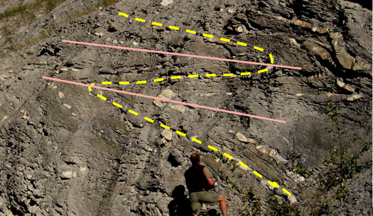
In order to help with the interpretation, one of the beds has been traced (in yellow) on the diagram below, and two of the fold axes have been shown (in pink). These folds are symmetrical, and although they are tight they are not isoclinal. They are overturned.
Practice Exercise 10.2 Types of faults
| Top left: a normal fault, implying extension |
| Bottom left: a series of normal faults, extension |
| Top right: A reverse fault, compression |
| Bottom right: a right lateral fault (implies that there is shearing, but it is not possible to say if there is extension or compression) |
