
6 Weather
Learning Outcomes
By the end of this section you should be able to:
- Interpret the origin of common wind systems;
- Describe effects of wind on the geosphere;
- Identify basic cloud types;
- Explain severe weather systems that impact humans.
Wind
Cyclonic and anticyclonic winds
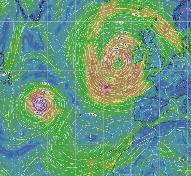
Large scale wind vortexes due to Coriolis and pressure-gradient effects are described as cyclones and anticyclones.
A low-pressure system (cyclone) has rising air and converging surface winds that spiral inward, counterclockwise in the northern hemisphere and clockwise in the southern hemisphere.
A high-pressure system (anticyclone) has descending air and diverging surface winds that spiral out clockwise in the northern hemisphere, counterclockwise in the southern hemisphere.

Examples of both are easy to find on the weather forecasting web-site windy.com
Wind patterns due to local heating and cooling
In areas away from cyclonic flow, local temperature effects may dominate wind patterns. One example is the occurrence of land and sea breezes in coastal areas.
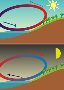
Sea breezes result from local pressure gradients. During the day, land heats faster than the sea, creating a region of low pressure and causing air to rise. For this reason, a sea breeze blows toward the land.
At night, land cools faster than the sea, leaving the sea warmer, creating a zone of low pressure. and causing air to rise. As a result, a land breeze blows toward the sea.
A similar daily wind cycle occurs in mountain-valley systems. During the day, low ground is warm, and high ground is heated by the sun. Warm air rises up mountain sides (valley wind). However, that warm air loses heat as it rises adiabatically, and further cooling at night results in a return air flow from high ground to low (mountain wind).
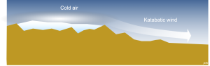
Katabatic winds are an intense form of mountain wind that occurs when very cold, dense air formed over a glacier or mountain range flows down into lower ground.
Orographic winds
Orographic winds are characteristic wind patterns associated with mountains. Many of these phenomena have local names given by populations that experience them.
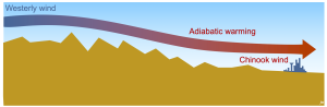
For example, Chinooks occur when regional flow forces west-to-east flowing air over the Rocky Mountains of western Canada. On the way up, water condenses because of adiabatic cooling. The descending air warms up again, but is now very dry.
Elsewhere in the world, different names are used for this phenomenon: Chinook in the Rockies, Föhn wind in Germany, Santa Ana wind in southern California, and Sirocco winds in areas of the Mediterranean.
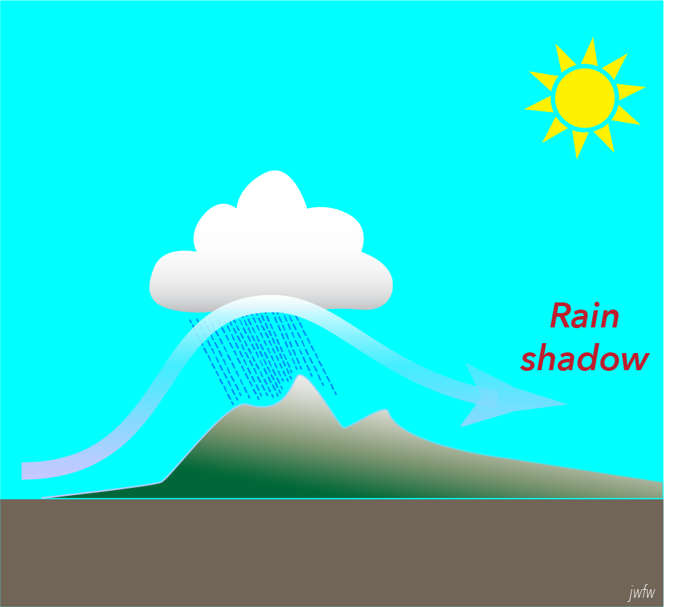
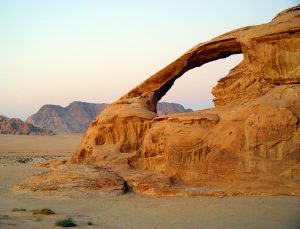
Prevailing wind patterns that lead to persistent dry air on one side of a mountain belt may produce an arid landscape with little rain. Such an area is called a rain shadow.
Movement of sediment by wind

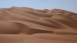
In dry landscapes, wind may be powerful enough to suspend sediment, producing sandstorms and dust storms.
- Dust or mud when smaller than 1/16 mm
- Sand when 1/16 mm to 2 mm
- (Particles larger than 2 mm, called gravel, are not normally moved by air flow.)
High-speed wind-blown sand is a powerful agent of weathering, the breakdown of solid rock of the geosphere, and erosion, the removal of that material from the site of weathering. Collisions between particles of sand, and collisions of sand with the land surface, are common. Typically these collisions cause the grains to become rounded, and over time they may wear away the solid rock, generating more sand in the process.

Wind is also able to sort sand so that all the grains in a typical wind-blown sediment are about the same size.
Sediment is deposited where wind weakens in strength. Moving air typically deposits sand in bedforms called dunes that have steep slopes on the downwind, or lee side, where sediment is deposited. In ancient sand dunes we can use this property to determine the wind direction when the sand was being deposited.

 Clouds
Clouds are visible aerosols consisting of liquid water droplets, ice particles, or a mixture of the two, formed when moist air is cooled below its dew point. Cloud close to the surface of the land or sea is called fog.
Clouds typically form when air rises. Adiabatic cooling reduces the temperature of an air mass, increasing relative humidity and eventually causing condensation. There are four basic ways air is forced to rise, cool and form clouds, although these four may operate in combination.
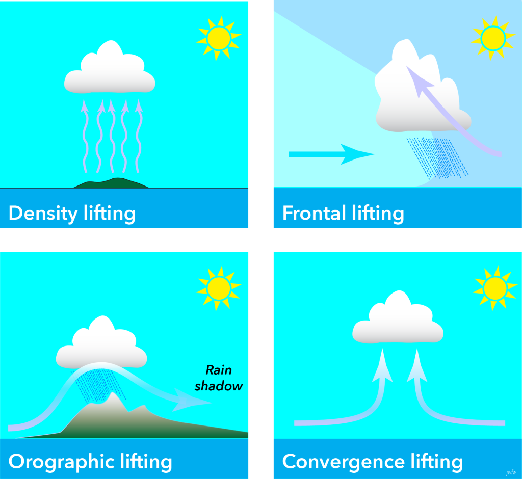
- Density lifting occurs because warm, lower-density air rises and expands.
- Frontal lifting occurs when the movement of air masses drives warm air over cold.
- Orographic lifting occurs where mountain ranges force air masses to rise.
- Convergence lifting occurs where air masses converge or collide, forcing air to rise.
As anybody who’s looked at the sky knows, there is an amazing variety of shapes and sizes of clouds, and in this section we will look at some of the basic cloud types that can be seen in Earth’s atmosphere.

There are three basic endmember cloud types: Cumulus, Cirrus, and Stratus. Between these end-members there is a spectrum of different cloud types. The names given to intermediate types indicate where they form in the atmosphere (high, intermediate, or low) and their relationships to the three main types.
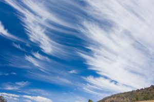
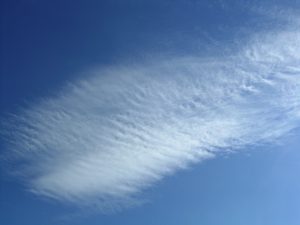
Cirrus clouds are wispy, high altitude clouds that typically form above 6 km up to the tropopause. They are typically ice-particle clouds.
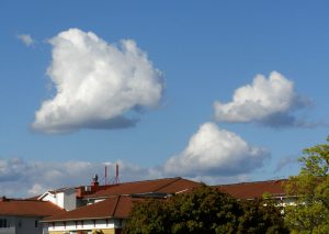
Cumulus means “heaped”. Cumulus clouds typically have flat bases and domed tops. They are water-droplet clouds. Cumulus clouds are of rising air that undergoes adiabatic cooling. The flat base is the surface where air reaches its dew point. Cumulus clouds generally form at altitudes of 1 to 2 km, but sometimes reach 6 km high.
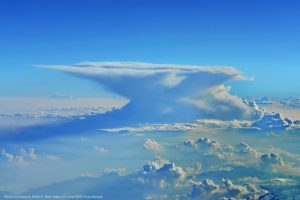
Cumulonimbus resembles Cumulus, but Cumulonimbus clouds may rise to very high altitudes, approaching the tropopause. Lightning is very common within Cumulonimbus clouds. In the upper troposphere, portions of a Cumulonimbus cloud may spread out laterally as an anvil. The spreading upper parts may contain mainly ice crystals and resemble cirrostratus.
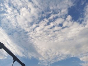
Altocumulus is a variant that forms at higher altitudes. Altocumulus clouds are generally broader and less tall than typical cumulus clouds.

Cirrocumulus clouds are very high clouds, made of ice particles, that nonetheless have a clumped appearance.
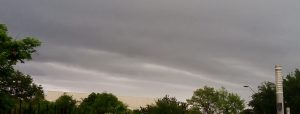
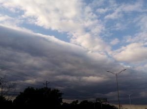
Stratus clouds form horizontal extensive flat layers, typically at low altitudes less than 2 km. They are mainly composed of water droplets, and are typical of the areas where warm air spreads laterally, as well as rising, above cold air.
Nimbostratus is stratus that is actively producing steady rain or snow.

Altostratus is a higher altitude variant of Stratus, that may be thinner and translucent, so that the Sun or Moon may shine through. It typically forms between 2 and 7 km.
Cirrostratus is a layer of ice cloud in the upper troposphere, above 7 km, that is thicker and more continuous than cirrus.
Stratocumulus clouds are horizontally extensive, and form at low altitude, but have domed or clumped features intermediate between stratus and cumulus.
Severe weather
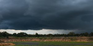
Thunderstorms
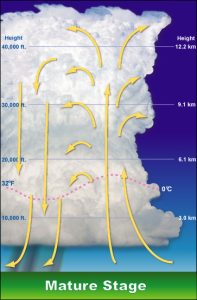
Thunderstorms form in warm moist air masses, during daytime heating, especially along cold fronts where mT air contacts cP air.
Density/frontal lifting leads to condensation, which releases latent heat.
High winds are drawn into the storm, and strong upward air flow carries ice particles upward repeatedly. The freezing of supercooled water can produce large hail.
Strong air currents cause the ionization of air molecules, such that the top of the cloud becomes positively charged and the base of the cloud becomes negatively charged. The electrical discharges that occur as a result of this separation of charge are lightning. Thunder is the resulting sound. Cloud-to-cloud and cloud-to-ground discharges can occur.
Tornadoes
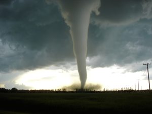
Tornadoes form in thunderstorms and are initiated in spiral updrafts. They are tightly rotating centres that typically (but not always) rotate in the cyclonic direction. Because of their small size (< 3 km diameter), tornadoes are not strongly affected by the Coriolis effect, and may rotate in either direction. A tornado is typically preceded by a funnel cloud (a rotating mass of cloud that doesn’t reach the ground. Winds in tornadoes have been known to reach 480 km/hr although winds less than 180 km/hr are more common. Extreme low pressures at the centre of tornadoes add to the destructive power of the high winds.
Tropical cyclones
s form just outside the ITCZ at 5-10° north or south of the equator. They require:
- Warm moist air (>26° C over the sea)
- Condensation to supply latent heat for continued density lifting
- The Coriolis effect to drive rotation.
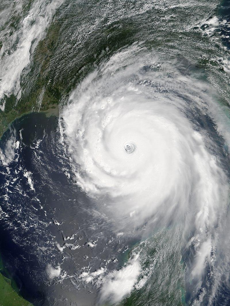
Tropical cyclones have different names in different parts of the world. In the Atlantic and east Pacific they are known as hurricanes, whereas in the west Pacific and north Indian oceans they are known as typhoons. Elsewhere the usual name is just tropical cyclone. Typically, these names are applied when sustained winds reach hurricane force of >120 km/hr. Less powerful systems are called tropical storms.
Tropical cyclones vary from <100 km to about 2000 km in diameter, most of which is occupied by thick cloud layers. Large systems may have a cloud-free eye surrounded by a wall of cloud (the eyewall) in which the fastest winds are recorded. The intense low pressure may raise the surface of the sea up to 13 m.
Most tropical storms drift from east to west, but many track away from the Equator and curve to the northeast at the western edge of the ocean in which they form. Tropical cyclones cause most damage when they cross populated coastal areas. The highest velocity winds and the most intense rainfall occur in the eyewall region, but belts of rain and lightning occur throughout the clouded area. The raising of the sea-surface by a hurricane creates a storm surge leading to major flooding of coastal areas, which may be exacerbated by abnormally high rainfall. Intense shearing between belts with different wind-speeds may generate tornadoes.
Monsoons
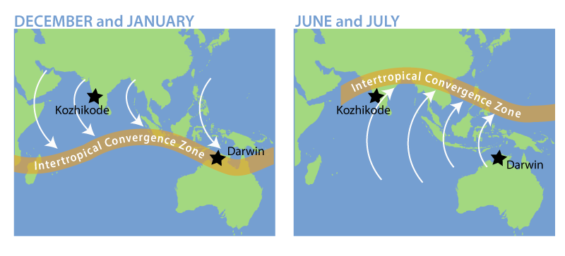
Monsoons are oscillations between very rainy and very dry seasons that affect parts of the world near the ITCZ. The ITCZ migrates north and south of the equator during the year as a result of the tilt of the Earth’s axis. For example, in the Indian subcontinent, the ITCZ migrates northward in the northern hemisphere summer until it lies over the Himalaya and other central Asian mountain ranges. Northward flow towards the ITCZ crosses the warm Indian Ocean picks up water vapour, and then is forced upwards (orographic lifting) as it crosses higher ground, causing adiabatic cooling and condensation. Depending on the area of the Indian subcontinent, monsoon rains may begin in mid-June and continue until November or December. In northern Australia, an oppositely directed seasonal air current brings heavy rainfall from October to April, while the ITCZ is positioned across Australia.
The apparent deflection of objects travelling over the surface of a rotating sphere, because of different rotation speeds at different latitudes
The flow of air from a region of high pressure to one of low pressure.
A region of low pressure with converging air circulation at low altitude, clockwise in the southern hemisphere, counterclockwise in the northern hemisphere
A region of high pressure with diverging air circulation at low altitude, clockwise in the northern hemisphere, counterclockwise in the southern hemisphere
Wind that blows from sea to land, typically during the day, caused when low pressure develops because of heating of the land by the sun. Cooler air from the sea replaces rising air over land.
Wind that flows from land to sea, typically caused as a high-pressure region forms on land as air cools rapidly at night
The rise of warm air up mountain sides during the day
The descent of cool, dense air from high ground into adjacent valleys
The descent of cold, dense air cooled by higher-altitude glaciers towards lower ground.
Wind patterns associated with mountains
Warm orographic wind adjacent to the Rocky Mountains of Canada. Cooler air descends from high altitudes and is warmed by adiabatic compression.
A suspension of sand in the troposphere by powerful winds.
A suspension of mud-sized particles in the troposphere by powerful winds.
Small particles or droplets suspended in the atmosphere.
A change to a system is adiabatic no heat energy is gained or lost during the change
Cloud with clumped domed tops and flat bases formed at low altitude where rising air reaches its dew point to form water droplets.
Wispy, high altitude clouds that typically form above 6 km up to the tropopause. They are typically ice-particle clouds.
Clouds that form horizontal, flat layers at low altitudes. Typical of warm fronts.
Towering clumped rain-producing cloud, typically terminated at the top with an anvil-shaped ice-cloud. Typically produces lighning and thunder.
A broad, short clumped cloud typically formed at moderately high altitudes.
High-altitude clouds composed of ice particles, but having a clumped appearance similar to lower-altitude cumulus.
Horizontal low-altitude cloud layers (stratus) that produce steady precipitation.
A thin, laterally continous transparent cloud similar to stratus but formed at moderately high altitudes. Altostratus clouds typically allow sunlight to penetrate through.
A layer of ice cloud in the upper troposphere, typically above 6 km, that is thicker and more continuous than cirrus.
Low altitude clouds that are generally horizontally extensive, like stratus, though displaying domed or clumped features resembling cumulus
A severe weather system with rain and/or hail together with electrical discharges (lightning) that cause thunder
Addition or removal or of electrons to/from atoms or groups of atoms, forming ions
A narrow and intense spiral updraft that commonly develops from a funnel cloud, and features very low pressure at its centre.
A cyclonic storm that develops north or south of the intertropical convergence zone. A storm must achieve a windspeed >120 km/hr to be considered a tropical cyclone.
A tropical cyclone a in the Atlantic and East Pacific
A tropical cyclone in the North Indian Ocean or West Pacific
Wind speed >120 km/hr; the wind speed required for a tropical system to be considered a tropical cyclone.
A cyclonic storm with a wind speed less than >120 km/hr that nevertheless forms from warm moist air north or south of the intertropical convergence zone
The cloud-free centre of a tropical cyclone where winds are at their calmest.
The wall of cloud surrounding the eye of a tropical cyclone where winds are particularly fast
Local rise in sea level along a coast beneath a major storm due to the combined effect of onshore wind and reduced air pressure
Climate characterised by oscillating dry and extremely wet seasons, caused by northward and southward movement of the intertropical convergence zone (ITCZ)
The rise of air as wind blows over hills or mountains
