
9 Water within the Geosphere: Groundwater
This chapter is a final draft; glossary entries need to be completed
Learning Outcomes
By the end of this section you should be able to:
- Define porosity and permeability, and describe how they affect groundwater flow;
- Define groundwater and groundwater zones;
- Describe the groundwater table its relationship to groundwater flow, and to zones of recharge and discharge;
- Describe the differences between aquicludes, confined aquifers and unconfined aquifers;
- Describe how dissolution and precipitation by groundwater affect landscapes and rock features, and how groundwater chemistry changes.
Importance of groundwater

Groundwater[1] is water below the Earth’s surface (in the geosphere) that fills spaces in regolith, soil, and rock. It probably comprises less than 2% of Earth’s water, but this is somewhat uncertain because quantifying the exact amount, especially at depth, is difficult. In addition, only the upper parts of the groundwater system (typically about the upper 500 m) are useful for humans, because water is difficult to pump to the surface, and because deeper waters are very slow moving, residing in the Geosphere for thousands or millions of years. Ancient groundwater tends to be very saline, and, furthermore, bringing it to the surface is difficult and expensive. If all this deep water is included, it is clear that there may be over 100 times more groundwater than surface water.
Groundwater in shallower parts of the Geosphere is a critical resource for human water supplies, agriculture, and industry, but groundwater may become contaminated by human activities. Groundwater contamination occurs out of sight, in the subsurface, so understanding how groundwater flows below the surface of the Geosphere is critically important for human health. Earth scientists who study groundwater are known as hydrogeologists[2].
Groundwater basics
Porosity and permeability
Groundwater is stored in spaces within rocks that are known as pores. Pores vary in size from microns across to tens of metres in diameter: very large pores include caves! Clearly, the amount of space is important to understanding groundwater. The proportion of pore space in a geologic medium (regolith, sediment, or rock) is known as the porosity; it may be measured either as a direct proportion (theoretically between 0 and 1 but more usually between 0 and 0.5) or as a percentage (typically between 0 and 50%)
Pore space may be may be filled by air, water, or other fluids (oil, natural gas), or combinations of these fluids.
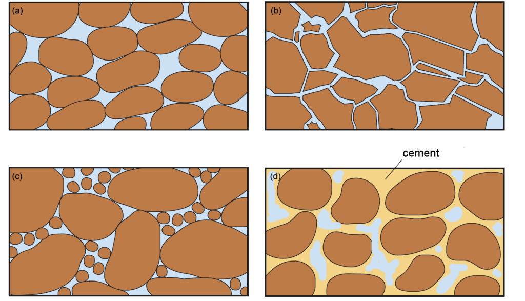
The above diagrams show porosity that was developed while sediment was being deposited, known as primary porosity. Usually porosity decreases over geologic time, but sometimes something happens to cause new pore spaces to develop. Cave systems may form, for example, by solution of pre-existing rock. Porosity that developed after the original formation of a rock is known as secondary porosity.
Permeability is a measure of how easily a fluid can flow through a material. Permeability depends on:
- porosity
- size of pore spaces
- connectedness of pore spaces
Permeability is measured in darcys[3] or, more usually, in millidarcys. (Loose sand, for example, may have a permeability of 500 millidarcies)
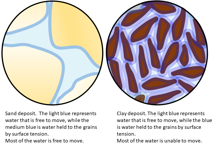
It is important to note that high porosity does not necessarily mean high permeability. For example, a fine-grained clay may have very high porosity (over 50%) but extremely low permeability because the pore spaces, though numerous, are very small. Attractive forces between the clay mineral surfaces and the film of water that surrounds them are very strong, making it very difficult to move water through clay.
What fills pores: groundwater and other fluids
Immediately below the land surface, porosity is mostly filled by air, although films of water may be present on the surfaces of rock and soil particles. The zone in which air is present in pore space is known as the aerated, unsaturated or vadose zone.
Below the vadose zone is a region where pore spaces are filled with water. This is known as the saturated zone of groundwater.
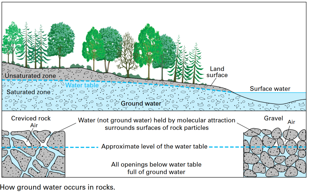

Below the water table, most porosity within the Geosphere is filled by liquid water. However, in arctic regions, pore water may be permanently filled instead by ice, producing permafrost, which is almost impermeable.
At the other extreme, in tectonically active areas, especially those with volcanic activity, groundwater may be heated, even to boiling point. Hot groundwater, known as hydrothermalwater, is responsible for spectacular phenomena like geysers when erupted at the Earth’s surface, and for many types of mineral deposit, some of them valuable to humans, when it cools or changes composition below the surface.
It is also possible for fluids other than water to be present at depth within rock porosity. Hydrocarbon compounds that fill rock porosity at depth include liquids (oil) and gases (natural gas). In general, these fluids do not mix with groundwater because they are non-polar substances that form separate phases. Regions within the Geosphere where these fluids are present in the pore spaces are known as petroleum reservoirs if they are large enough to be extracted by humans.

The water table
The vadose and saturated zones are separated by a boundary called the water table. It’s important to remember that the water table is a surface[4] within the uppermost part of the Geosphere.
The water table is typically a subdued imitation of the topographic surface, the landscape; it is higher below hills and lower below valleys.
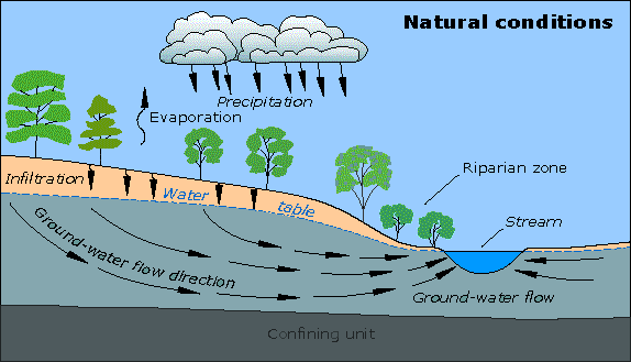
The position of the water table also varies with season. During low precipitation and/or infiltration, the water table falls. During times of recharge (for example, rain events and spring melt), the water table rises.
The exact position of the water table is controlled by a combination of recharge (the addition of water to the saturated zone), discharge (removal of water from the saturated zone) and the physical properties — porosity and permeability — of the medium (soil, sediment, or rock).

Surface water bodies, such as rivers, lakes, ponds and wetlands, typically occur where the topographic surface intersects the groundwater table. Therefore, many surface waters are partially fed by base flow of groundwater.
Groundwater flow
Recharge occurs when water enters the subsurface and becomes groundwater.
Discharge[5] is the process that returns groundwater to the surface of the Geosphere. Typically, this occurs where the water table intersects the land surface, allowing water to escape from the saturated zone.
Below the water table, groundwater flow is governed by laws similar to those that determine flow in the Atmosphere. Water flows from regions of higher pressure to regions of lower pressure. However, water flow within the Geosphere is strongly affected by permeability. As a result, groundwater flows much more slowly than air or water above the Earth’s surface. Groundwater flow rates are typically measured in metres per year, or even per century. Groundwater flow is much too slow to show the Coriolis effect
Usually, the pressure difference that drives water flow is provided by gravity, acting upon differences in the elevation of the water table. Hence it is usual to represent the pressure difference, or hydraulic potential, as a hydraulic head — the height of an equivalent water column. Water flows from high hydraulic head to lower hydraulic head, which usually means from places where the water table is high to places where the water table is low.
<diagram symblolizing hydraulic head>
Because the water table typically mirrors the topographic surface in a subdued way, this means that groundwater often flows from topographically high regions, such as hills or mountains, to topographically low valleys and plains where it may undergo discharge as base flow into streams or lakes.


Groundwater discharge
A region of discharge is a place where groundwater emerges at the surface. Common discharge areas include springs and surface water bodies such as rivers, lakes, and wetlands).
Springs are natural points of groundwater discharge that occur when the water table or a permeability boundary intersects the land surface.

Streams (especially in Canada) are often in areas of discharge, and groundwater contributes to their base flow. A stream that increases flow downstream due to base flow is called a gaining stream. However, some streams may decrease in flow downstream if the water recharges groundwater; such streams are called losing streams. In places where flow rates are very episodic, and the permeability of the ground is low, streams may even be disconnected from the water table and the saturated zone.

Aquifers and aquicludes
Aquifers are units within the outermost Geosphere that have sufficient capacity and high enough permeability to supply water at a rate useful to humans. Aquitards are units of geologic media that considerably slow or stop the flow of water (that is, they have low permeability), and aquicludes have permeability so low that there is no measurable flow of water through them. Aquicludes and aquitards may divide up the subsurface so that different types of aquifers are present.

Unconfined aquifers
An unconfined aquifer is one in which the upper boundary is defined by the water table. Pumping water from an unconfined aquifer leads to a lowering of the water table (known as drawdown) producing a drawdown cone or cone of depression in the water table.

The cone deepens until the rate of inflow balances the rate of withdrawal of water. The slope of the cone provides the hydraulic head necessary for the continuing flow of water into the well.
However, cones of depression can change the slope of the water table in unexpected ways. In the example below, the first diagram shows a house that is supplied by a groundwater well. The septic system is located downslope, and the flow of groundwater takes any water that is contaminated by sewage away from the fresh water supply. In the second diagram, the homeowners have installed an irrigation system for an orchard, which draws far more water than before. The new, large cone of depression has altered the slope of the water table below the house, so that sewage can now enter the domestic water supply.

Confined aquifers and Artesian wells
A confined aquifer is one in which the upper boundary is defined by an aquitard or aquiclude. The lower aquifer in the diagram is confined, except in its recharge area at the extreme right.

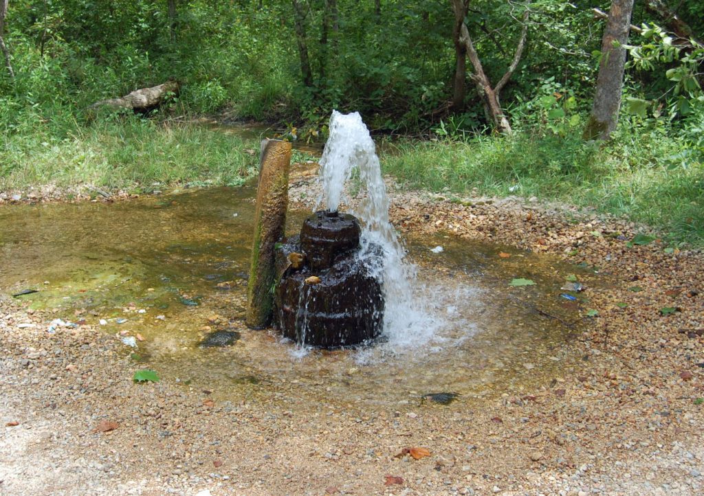
The water in a confined aquifer may be under pressure, as shown in the diagram. Such aquifers are described as artesian[6]. It’s possible to define a potentiometric surface for an artesian aquifer, which is the level to which water would rise of its own accord if a well were drilled into the aquifer. If a well is drilled from land above the potentiometric surface, water will rise part way up the well without pumping (a nonflowing artesian well). If, on the other hand, the well is drilled from land below the potentiometric surface, water will fountain out of the well, without pumping; this is termed a flowing artesian well.
<image of flowing artesian well>
Solution and precipitation by groundwater
Groundwater may partially dissolve materials that it passes through. The rate of solution depends on
- the starting composition of the groundwater, especially its pH
- the composition and type of surrounding rock
- the temperature and pressure
Karst topography
Rocks made of calcium carbonate (limestone and marble) are particularly susceptible to solution, especially by groundwater that is acid (e.g. because it has absorbed carbon dioxide as it passed through the Atmosphere).
Dissolution of limestone and other soluble rock types leads to the formation of cave systems, sinkholes (collapsed cave roofs), and pillars of rock isolated by dissolution of surrounding materials. Together, these features combine to make a characteristic topography known as karst.

Other features common in karst terrane include streams and valleys that appear to rapidly lose water in a downstream direction (disappearing streams and blind valleys). Where vegetation is thin, karst areas may display barren limestone pavement marked by cracks (known as joints) that have been widened by solution to produce a pattern of crevices.

<photos of karst features: sinkhole, tower karst, disappearing stream? limestone pavement>


Although limestone (calcium carbonate) produces the most abundant karst topography, karst features may develop over other soluble rock types such as gypsum (hydrated calcium sulphate).
Groundwater composition
Groundwater that has carried out solution may of course carry much of the dissolved material. The amount of dissolved mineral material in groundwater is called the salinity. Salinity is typically measured in parts per million (ppm).
Groundwater may classified according to its salinity:
- Fresh water (< 1000 ppm dissolved solids)
- Brackish water (1000 – 10,000 ppm)
- Saline water (10,000 – 35,000: same as seawater)
- Brine, or hypersaline water (> 35,000 ppm)
Overall, the salinity of groundwater depends on
- The speed of groundwater flow. In general, slow moving groundwater has more time to acquire increased salinity;
- The type of rock it has passed through. Highly soluble materials like rock salt may rapidly increase the salinity of groundwater;
- pH: acidic (low pH) groundwater is more effective at dissolving most rocks;
- Temperature: solution reactions go faster if the temperature is raised.
As a result, deep, slow-moving groundwater is typically saline, and not suitable for human consumption. An extreme case is water that has been trapped in sedimentary rocks since they were deposited, known as connate water, which is commonly not drinkable.
Precipitation of minerals from groundwater
Because groundwater may carry high concentrations of mineral material, when conditions change that material may be precipitated as solids that start to fill the pore spaces through which the water is travelling. Precipitation of minerals occurs when ions dissolved in groundwater come out of solution due to changes in factors such as pH, temperature, pressure, or the effects of evaporation. This is especially true of hydrothermal (hot) water, which may form important mineral deposits when the temperature falls or when chemical conditions change.
Cement
Mineral deposits in small pore spaces are called cement. Cement may convert a loose sand into a hard sandstone (lithification), an aquifer into an aquiclude, and make a potential oil or natural gas reservoir into a non-porous, or “tight”, rock.

Note that, despite its name, cement does not have to glue a rock together. For example, crystals formed inside the fossil shells of animals are still called cement, because they fill porosity, even though they may not play a role in the hardening (lithification) of the rock in which they are found.

Veins and geodes

Dissolved mineral material may precipitate in cracks and larger pores in the saturated zone as veins or geodes. Veins are natural cracks (known as joints) that have become filled by minerals, typically precipitated from hydrothermal water. Geodes are more spherical cavities that have been partially filled by crystals growing within groundwater. Spectacular crystal shapes may be exposed when the geode is broken open.
When crystals grow to completely fill the space inside a joint or other cavity, they interfere with one another and don’t usually show clear crystal shapes. Although such mineral deposits are less attractive as collectables, the minerals they contain may be valuable.
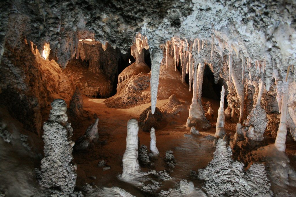
Dripstone and caves
When cement is precipitiated in the vadose zone, it is typically because water has evaporated into vapour within the air-filled pore spaces, leaving the dissolved mineral material behind. Vadose cement typically coats surfaces with a smooth layer, without developing large crystals. In caves that are largely air-filled, calcium carbonate coatings formed this way are known as dripstone. Dripstone may form spectacular features in caves including stalactites (pointed shafts hanging from the ceiling) or stalagmites (more rounded domes growing from the cave floor). Stalactites and stalagmites grow from repeated drops of water that hang from the ceiling while evaporating, and then fall on the floor below, depositing more calcium carbonate there.
- The terms groundwater and ground water have different definitions in different texts. In some, the term groundwater is restricted to water in the saturated zone, below the water table. In other publications, it is restricted to the upper 450 m of the Geosphere, where usable water mostly resides. In this document we use "groundwater" in the most inclusive sense, to include all liquid water within the Geosphere, recognizing that this includes a great deal of water (up to two thirds of the total) that cannot usefully be extracted or used by humans. ↵
- Hydrogeologists study groundwater whereas hydrologists study water on the surface. ↵
- named after the French engineer Henri Darcy, who predicted the flow of water through porous media using a relationship known as Darcy's law. The darcy is not an SI unit but is commonly used in groundwater studies. ↵
- News reports that speak of the water table as if it is a container (expressions like 'contamination of the water table') are incorrect. Such reports really mean that contaminants have passed through the water table into the saturated zone. ↵
- This use of the term is different from (though related to) the use of the term in the study of rivers, where it refers to the measured flux of water passing through a part of the Hydrologic System. ↵
- The term 'artesian' comes from Artois in France, a region where many artesian wells were drilled from 1126 CE onwards. ↵
Water that occupies spaces within the Geosphere
A scientist who studies groundwater
The proportion or percentage of space in a solid that may be filled by fluids.
Porosity developed at the time a rock is formed
Porosity formed by solution, at some time after deposition of the rock
A unit of permeability. A permeability of one darcy allows one cubic centimetre per second of fluid having a viscosity of one centipoise through a sample with a cross-section of one square centimetre under a pressure gradient of one atmosphere per centimetre. The SI equivalent of one darcy would be 9.87 x 10⁻¹² m².
A unit of permeability equal to one thousadth of a darcy
In groundwater study, the zone above the water table where pore spaces are partly filled by water. (Also known as the aerated zone.)
The groundwater zone where pore spaces are entirely filled by water.
Material near the Geosphere surface that remains frozen for two or more years.
Hydrothermal describes groundwater that has been heated by geothermal energy
A compound constructed from carbon-carbon and carbon-hydrogen bonds.
Liquid Petroleum; organic matter that has undergone burial and subsequently been transformed into hydrocarbon-rich liquid.
Hydrocarbon-rich gas derived from sedimentary organic matter.
The part of a system that is separated from other parts by distinct boundary surfaces; for example water exists in three phases: solid ice, liquid, and vapour, which do not mix.
A volume of porous rock within the Geosphere that contains oil or natural gas in sufficient quantity to be extracted
The divide between the saturated and vadose zones of groundwater.
The addition of water over time to a groundwater reservoir
The ability of a solid to and allow fluid to move through it.
Water transported into a channel through groundwater flow into the base of the stream
The total rate of flow passing through a point of a stream, calculated as a volume per second or alternatively the product of velocity and cross-sectional area
Tthe height of a water column that would produce the observed groundwater pressure difference between two locations. Groundwater flows from the location of high head to low head.
Natural points of groundwater discharge that occur when the water table or a permeability boundary intersects the land surface.
Streams that increase their discharge in a downstream direction as a result of base flow from groundwater.
Streams that lose discharge downstream by recharging groundwater.
